First detailed map of aboveground forest carbon stocks in Mexico unveiled
2014-10-16
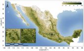
(Press-News.org) Available for download today, the Woods Hole Research Center (WHRC) and Allianza MREDD+ released the first detailed map of aboveground forest carbon stocks of Mexico. This carbon stock inventory is very valuable for Mexico, as one of the first tropical nations to voluntarily pledge to mitigation actions within the context of the United Nation's Reducing Emissions from Deforestation and forest Degradation (REDD+) program.
The hectare-scale map is the result of a collaboration led by WHRC scientists Josef Kellndorfer and Oliver Cartus with Mexico's National Forestry Commission (CONAFOR) and the Mexican Norway Project (MNP) to provide a tool for the national government to enhance a robust Measurement, Reporting and Verification (MRV) system for national carbon emissions.
"The release of this data set is an important step forward in the accounting for carbon flux in Mexico and in supporting efforts to reduce carbon emissions from the land sector," says Dr. Kellndorfer. "We see the potential for these biomass data sets to be generated by other tropical nations." The map integrates Mexico's National Forest Inventory (INFyS), which provides field measurements for 26,000 plots across Mexico with spatial image data from the Japanese ALOS PALSAR radar and U.S. Landsat satellite sensors, which contain complementary information on forest density and structure. The fusion of these three datasets allows for continuous estimates of carbon stocks where field data are missing even for those classes not very well represented in the national forest inventory. The team is currently testing airborne lidar data in a range of Mexico's ecosystems as an option to augment field observations with airborne and satellite data to improve carbon mapping for countries without detailed forest inventories.
Rane Cortez from The Nature Conservancy, Chief of Party of the Allianza MREDD+ states, "Mexico is quickly becoming a leader on REDD+ and can serve as a model for other countries. This biomass map and dataset represent one of the important advancements that Mexico has made in developing its national monitoring system and will help the country prioritize its strategies and investments for reducing emissions from deforestation."
INFORMATION:
The maps and findings were published as "A National, Detailed Map of Forest Aboveground Carbon Stocks in Mexico" in the journal Remote Sensing.
For more information and to obtain data access, please visit
http://whrc.org/mapping/pantropical/mexcarbon/mex_dataset.html
For further information on Allianza MREDD+ work in Mexico:
http://www.alianza-mredd.org/
The Woods Hole Research Center is an independent research institution where scientists investigate the causes and effects of climate change to identify opportunities for conservation, restoration and economic development around the globe.
[Attachments] See images for this press release:

ELSE PRESS RELEASES FROM THIS DATE:
2014-10-16
1. Conventional medical centers may be unable to prevent spread of Ebola
A group of infectious disease experts suggests that conventional U.S. medical centers are unprepared and ill equipped to manage Ebola and a national network of specialized containment and treatment facilities may be needed to reduce the virus' spread, according to an article being published in Annals of Internal Medicine. Despite efforts from the Centers for Disease Control and Prevention (CDC) to prepare hospitals for Ebola, enormous challenges remain. The authors express doubt that conventional ...
2014-10-16
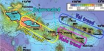
A UC Santa Barbara geochemist studying Samoan volcanoes has found evidence of the planet's early formation still trapped inside the Earth. Known as hotspots, volcanic island chains such as Samoa can ancient primordial signatures from the early solar system that have somehow survived billions of years.
Matthew Jackson, an associate professor in UCSB's Department of Earth Science, and colleagues utilized high-precision lead and helium isotope measurements to unravel the chemical composition and geometry of the deep mantle plume feeding Samoa's volcanoes. Their findings ...
2014-10-16
VIDEO:
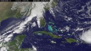
NOAA's GOES-East satellite captured this image of Hurricane Gonzalo off the U.S. East Coast on Oct. 16 at 13:07 UTC (9:07 a.m. EDT).
Click here for more information.
NASA and NOAA satellites have been providing continuous coverage of Hurricane Gonzalo as it moves toward Bermuda. NASA's Terra satellite saw thunderstorms wrapped tightly around the center with large bands of thunderstorms wrapping into it. NOAA's GOES-East satellite provided and "eye-opening" view of Gonzalo, ...
2014-10-16
Tropical Storm Ana continued on a path to the Hawaiian Islands as NASA's Terra satellite passed overhead and gathered data on the storm. NOAA's GOES-West satellite data was compiled into a movie that showed the intensification and movement of Ana. Watches are now in effect for Hawaii.
NOAA's Central Pacific Hurricane Center (CPHC) has issued a Tropical Storm Watch for Hawaii County, Hawaii. A tropical storm watch means that tropical storm conditions are possible within the watch area, in this case within 36 to 48 hours. Life-threatening surf and riptide conditions will ...
2014-10-16
An international team of scientists has succeeded in explaining the formation and propagation over astronomical distances of jets of matter emitted by young stars—one of the most fascinating mysteries of modern astronomy. Using a patented experimental device and large-scale numerical simulations, the team obtained data consistent with astrophysical observations. The results of this research—just published in the prestigious journal Science—open up new opportunities for studying the role of magnetic fields in astrophysics and thermonuclear fusion. Bruno ...
2014-10-16
Why is the Sun's million-degree corona, or outermost atmosphere, so much hotter than the Sun's surface? This question has baffled astronomers for decades. Today, a team led by Paola Testa of the Harvard-Smithsonian Center for Astrophysics (CfA) is presenting new clues to the mystery of coronal heating using observations from the recently launched Interface Region Imaging Spectrograph (IRIS). The team finds that miniature solar flares called "nanoflares" - and the speedy electrons they produce - might partly be the source of that heat, at least in some of the hottest parts ...
2014-10-16
Researchers at the University of Connecticut have found a new way to identify protein mutations in cancer cells. The novel method is being used to develop personalized vaccines to treat patients with ovarian cancer.
"This has the potential to dramatically change how we treat cancer," says Dr. Pramod Srivastava, director of the Carole and Ray Neag Comprehensive Cancer Center at UConn Health and one of the principal investigators on the study. "This research will serve as the basis for the first ever genomics-driven personalized medicine clinical trial in immunotherapy ...
2014-10-16
Antibiotic-resistant bacteria can share resources to cause chronic infections, Vanderbilt University investigators have discovered. Like the individual members of a gang who might be relatively harmless alone, they turn deadly when they get together with their "friends."
The findings, reported Oct. 8 in Cell Host & Microbe, shed light on a long-standing question in infectious diseases and may inform new treatment strategies, said Eric Skaar, Ph.D., MPH, Ernest W. Goodpasture Professor of Pathology, Microbiology and Immunology.
One way that Staphylococcus aureus and other ...
2014-10-16
Using the NASA/ESA Hubble Space Telescope astronomers have made what may be the most reliable distance measurement yet of an object that existed in the Universe's formative years. The galaxy is one of the faintest, smallest and most distant galaxies ever seen and measuring its distance with this accuracy was possible due only to the incredibly detailed mapping of how giant galaxy clusters warp the space-time around them.
Astronomers often use gravitational lensing -- the magnifying power of galaxy clusters -- to find distant galaxies [1]. However, when it comes to the ...
2014-10-16
Boulder, Colo., USA - What is the "Sixth Extinction"? How do paleontologists determine North America's future fire threats? What do trilobites look like on the inside? Did the Chicxulub impact trigger an eruption? Here, the Paleontological Society highlights some of the best science and current work in paleontology to be presented at the 126th Annual Meeting of The Geological Society of America on 19-22 October in Vancouver, BC, Canada.
SUNDAY, 18 Oct.
Geospatial Analysis of Human-Megafaunal Overlap in North America: Lead author Meaghan Emery and colleagues write that ...
LAST 30 PRESS RELEASES:
[Press-News.org] First detailed map of aboveground forest carbon stocks in Mexico unveiled


