How is deforested land in Africa used?
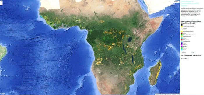
With satellite data and machine learning methods, it is possible to identify and locate 15 forms of land use – from the cultivation of various crops to pastureland and mining
Africa's forested areas – an estimated 14 % of the global forest area – are continuing to decline at an increasing rate – mostly because of human activities to convert forest land for economic purposes. As natural forests are important CO2 and biodiversity reservoirs, this development has a significant impact on climate change and effects the integrity of nature. To intervene in a targeted manner in the interests of climate protection and biodiversity, there has been a lack of sufficiently good data and detailed knowledge of the various forms of subsequent utilisation of deforested areas to track where forest-related conversions are happening and why. This has now been provided by a new study published in the journal Nature Scientific Reports and led by Robert N. Masolele and Johannes Reiche from Wageningen University in the Netherlands, Martin Herold from the GFZ German Research Centre for Geosciences in Potsdam, and their team. They used high-resolution satellite data, which they analysed on the basis of local reference data for 15 different types of land use – from crops such as coffee, cashew and rubber to pastureland and mining – with the help of deep learning methods. This enabled them to create the first high-resolution (accurate to five metres) and continental mapping of land use after deforestation across a wide area of the African continent, including wet and dry forests. This provides an improved basis for enhancing transparency on where commodity expansion leads to deforestation and for underpinning the strategic planning and implementation of deforestation mitigation measures by governments and forest protection agencies – both in Africa and in the EU, where a new EU-regulation aims to establish “deforestation-free supply chains” for products made from certain raw materials.
Background: Africa's threatened forests and the EU Deforestation Regulation
Over the last two decades, Africa has experienced a rapid decline in forest areas and tree cover. How land use develops after deforestation has a significant impact on forest biomass, biodiversity and the water cycle. These changes can vary depending on the location, intensity and spatial extent of forest loss. Understanding the spatio-temporal extent and motives of deforestation in Africa is critical to understanding and mitigating its contribution to greenhouse gas emissions and the negative impacts on the forest ecosystem.
The EU also wants to make an important contribution to curbing forest loss. The European Union’s Deforestation Regulation (EUDR) is a new initiative which aims to ensure that products placed on the EU market are deforestation-free and therefore protect the world's forests for future generations. It also promotes transparency and traceability in supply chains, making it easier for consumers to make informed choices about the products they purchase.
Insufficient database to date
Although there are some national and regional statistics documenting trends in forest loss, there is a lack of consistent, detailed and spatially explicit estimates and mapping of the factors responsible for forest loss. Available information is often only based on samples at individual points in time, is not available in sufficient spatial-temporal resolution and thematic classification and has so far only included dry forests. Interpretations are often based on visual inspection of satellite images and on the historical expectation that different forms of subsistence agriculture persist and that certain land uses are restricted to specific geographical locations. This overlooks the diversity of actual causes of forest loss.
Comprehensive approach to mapping with high-resolution satellite data and Deep Learning Methods
In a comprehensive study, researchers led by Robert N. Masolele, post-doctoral researcher at Wageningen University in the Netherlands, and Martin Herold, Head of Section 1.4 “Remote Sensing and Geoinformatics” at the GFZ German Research Centre for Geosciences and Professor at the University of Potsdam, have now deciphered the complex patterns of land use that emerge after deforestation in Africa's diverse landscapes. They present the first comprehensive map of land use after deforestation in Africa, covering forest loss from 2001 to 2020. The map is available with a spatial resolution of five metres and 15 land use classes: from crops such as cocoa, cashew, oil palm, rubber, coffee and tea to mining, roads, settlements, grazing land, small and large-scale agriculture as well as plantation forest and other land with tree cover.
On the one hand, the researchers relied on the high-resolution Planet NICFI satellite data provided by Norway's International Climate & Forests Initiative (NICFI). Accordingly, the study was conducted on the African continent between 30 degrees north latitude and 30 degrees south latitude and includes countries in western, central, eastern and southern Africa. The region is characterised by both humid and dry forests.
Secondly, they used reference data from various publications, some of which were obtained via crowd-sourcing with the help of citizen science or from other remote sensing campaigns and open data sources.
“What makes this study special is the innovative use of satellite imagery, machine learning algorithms and active learning. This allowed us to accurately identify post-deforestation land use, map it at an unprecedented scale and level of detail, and assess the trend and hotspots of land use conversion in different countries and regions of Africa,” explains Robert N. Masolele, lead author of the study.
The most important results
The study reveals a complex web of land uses that emerge after deforestation events. It shows that the causes of forest loss vary from region to region. In general, small-scale cropland is the main driver of forest loss in Africa, with hotspots in Madagascar and the Democratic Republic of Congo. In addition, commodity crops such as cocoa, oil palm and rubber are dominant drivers of forest loss in the humid forests of western and central Africa, forming an “arc of commodity expansion” in that region. At the same time, the hotspots for cashew are found to increasingly dominate in the dry forests of both western and south-eastern Africa, while larger hotspots for large-scale croplands were found in Nigeria and Zambia. The increased expansion of cacao, cashew, oil palm, rubber, and large-scale croplands observed in humid and dry forests of western and south-eastern Africa suggests they are vulnerable to future land-use changes by commodity crops.
Classification and outlook
Although the mapping is very extensive, the study recognises that it is difficult to classify certain forms of land use with a high degree of accuracy. Factors such as cloud cover and seasonal variations present limitations that emphasise the need for continuous refinement and validation.
“The study makes a crucial contribution to our understanding of the complex interplay between human economic activities and the environment. Its particular importance lies in the fact that it provides policy makers, conservationists and scientists with a detailed understanding of the different developments that land undergoes in large parts of Africa after deforestation. This knowledge is crucial for developing targeted conservation strategies, achieving the Sustainable Development Goals and mitigating the environmental impacts of deforestation across the African continent,” emphasises Martin Herold. “We in Europe will also benefit from this, as the new EU deforestation regulation requires proof of deforestation-free supply chains for certain raw materials such as coffee, cocoa and rubber.”
Overall, this new study showcases the great potential of using high-resolution satellite data, combined with artificial intelligence and regional knowledge to provide open-source information for different stakeholders and enhance the transparency for tracking critical forest-related land use transitions in tropical forests.
END
Attachments