NASA saw Tropical Storm Guchol's rainfall drench Japan
Published 2012-06-22 · Original archive entry · Explore research explainers
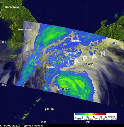
The first tropical storm of the season to make landfall in Japan was a soaker, and the Tropical Rainfall Measuring Mission (TRMM) satellite captured its large area of rainfall as it moved over the big island.
The TRMM satellite passed above weakening typhoon Guchol on June 18, 2012 at 2322 UTC (7:33 p.m. EDT) as it moved toward Japan's main island of Honshu. A precipitation analysis from TRMM's Microwave Imager (TMI) and Precipitation Radar (PR) instruments showed that the Japanese islands of Kyushu and Shikoku were getting rainfall from Guchol at the time of that orbit. Guchol was shown by TRMM to be enhancing rainfall in parts of Japan over 500 km (~310.7 miles) from the typhoon's center.
The Joint Typhoon Warning Center issued their final bulletin on Guchol on June 19 at 1500 UTC (11 a.m. EDT). At that time, maximum sustained winds were down to 35 knots (40 mph/64 kph). It was located about 110 miles (177 km) west of Yokosuka, Japan, near 35.3 North and 137.5 East and speeding to the northeast at 37 knots (42.5 mph/68.5 kph)!
Guchol re-emerged over the Pacific Ocean as a fully extra-tropical cyclone and will continue to weaken at sea.
INFORMATION:
The TRMM satellite passed above weakening typhoon Guchol on June 18, 2012 at 2322 UTC (7:33 p.m. EDT) as it moved toward Japan's main island of Honshu. A precipitation analysis from TRMM's Microwave Imager (TMI) and Precipitation Radar (PR) instruments showed that the Japanese islands of Kyushu and Shikoku were getting rainfall from Guchol at the time of that orbit. Guchol was shown by TRMM to be enhancing rainfall in parts of Japan over 500 km (~310.7 miles) from the typhoon's center.
The Joint Typhoon Warning Center issued their final bulletin on Guchol on June 19 at 1500 UTC (11 a.m. EDT). At that time, maximum sustained winds were down to 35 knots (40 mph/64 kph). It was located about 110 miles (177 km) west of Yokosuka, Japan, near 35.3 North and 137.5 East and speeding to the northeast at 37 knots (42.5 mph/68.5 kph)!
Guchol re-emerged over the Pacific Ocean as a fully extra-tropical cyclone and will continue to weaken at sea.
INFORMATION: