NASA sees strong thunderstorms in Tropical Storm Gaemi
Published 2012-10-03 · Original archive entry · Explore research explainers
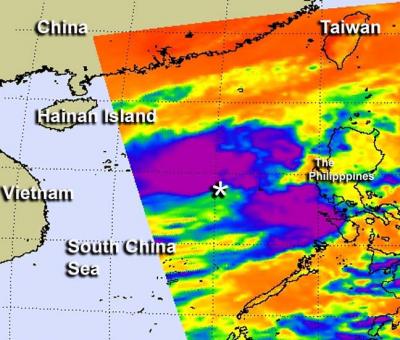
Infrared NASA satellite imagery revealed that the strongest thunderstorms within Tropical Storm Gaemi in the western North Pacific Ocean were located around the storm's center and in a band of thunderstorms east of the center.
On Oct. 2, 2012 at 1500 UTC (11 a.m. EDT) Tropical Storm Gaemi had maximum sustained winds near 40 knots (46 mph/74 kph). It was located about 515 nautical miles (592 miles/954 km) east of Hue, Vietnam, near 15.3 North latitude and 116.7 East longitude. Gaemi is moving to the southeast at 9 knots (10 mph/16.6 kph).
Infrared imagery from the AIRS (Atmospheric Infrared Sounder) instrument aboard NASA's Aqua satellite captured an image of Tropical Storm Gaemi on Oct. 2 at 0517 UTC (1:17 a.m. EDT). The most powerful thunderstorms with coldest cloud top temperatures were near -63 Fahrenheit (-52 Celsius) around the center and in a band of thunderstorms east of the center of circulation.
Satellite imagery shows that Gaemi is slightly elongated which is a sign of disorganization. However, Gaemi is expected to become more circular over the next couple of days and intensify. Satellite imagery also shows that a band of thunderstorms are wrapping into the low-level center which is a sign of strengthening.
By Oct. 4, a sub-tropical ridge (elongated area) of high pressure is expected to develop over southeastern China and that will help steer Gaemi west toward Vietnam.
Gaemi is forecast to slowly turn west toward the Vietnamese coastline and make landfall south of Hue by Oct. 6.
INFORMATION:
On Oct. 2, 2012 at 1500 UTC (11 a.m. EDT) Tropical Storm Gaemi had maximum sustained winds near 40 knots (46 mph/74 kph). It was located about 515 nautical miles (592 miles/954 km) east of Hue, Vietnam, near 15.3 North latitude and 116.7 East longitude. Gaemi is moving to the southeast at 9 knots (10 mph/16.6 kph).
Infrared imagery from the AIRS (Atmospheric Infrared Sounder) instrument aboard NASA's Aqua satellite captured an image of Tropical Storm Gaemi on Oct. 2 at 0517 UTC (1:17 a.m. EDT). The most powerful thunderstorms with coldest cloud top temperatures were near -63 Fahrenheit (-52 Celsius) around the center and in a band of thunderstorms east of the center of circulation.
Satellite imagery shows that Gaemi is slightly elongated which is a sign of disorganization. However, Gaemi is expected to become more circular over the next couple of days and intensify. Satellite imagery also shows that a band of thunderstorms are wrapping into the low-level center which is a sign of strengthening.
By Oct. 4, a sub-tropical ridge (elongated area) of high pressure is expected to develop over southeastern China and that will help steer Gaemi west toward Vietnam.
Gaemi is forecast to slowly turn west toward the Vietnamese coastline and make landfall south of Hue by Oct. 6.
INFORMATION: