(Press-News.org) Boulder, Colo., USA – For decades, planetary geologists have speculated that glaciers might once have crept through Valles Marineris, the 2000-mile-long chasm that constitutes the Grand Canyon of Mars. Using satellite images, researchers have identified features that might have been carved by past glaciers as they flowed through the canyons; however, these observations have remained highly controversial and contested.
Now, a joint team from Bryn Mawr College and the Freie Universitaet Berlin has identified what could be the first mineralogical evidence of past glaciers within the Valles Marineris: a layer of mixed sulfate minerals halfway up the three-mile-high cliffs of Ius Chasma at the western end of the canyon system.
The team -- including Selby Cull (Bryn Mawr College), Patrick McGuire and Christoph Gross (Freie Universitaet Berlin), and Bryn Mawr undergraduate student researchers Jenna Myers and Nina Shmorhun -- mapped the acid-sulfate mineral jarosite along the canyon wall. They speculate that it may have formed via a mechanism similar to one observed at glaciers in the Svalbard on Earth: Atmospheric sulfur becomes trapped in the ice, is warmed by the sun, and reacts with the water to produce highly acidic sulfate minerals like jarosite along the margins of the glacier.
FEATURED ARTICLE
A new type of jarosite deposit on Mars: Evidence for past glaciation in Valles Marineris?
Selby Cull et al., Dept. of Geology, Bryn Mawr College, Bryn Mawr, Pennsylvania 19010, USA, and Planetary Sciences and Remote Sensing Group, Institute of Geological Sciences, Dept. of Earth Sciences, Freie Universitaet Berlin, Berlin 12249, Germany. Published online ahead of print on 26 Sept. 2014; http://dx.doi.org/10.1130/G36152.1.
Other recently posted Geology articles (see below) cover such topics as
The geomorphology of Earth's Moon;
A finding that rockfalls in Christchurch, New Zealand, during the 2011 earthquakes were of similar extent and severity at the same sites approximately 7,000 years ago;
Research to help resolve "Darwin's dilemma"; and
Earthquakes and the nature of Klyuchevskoy volcano in Kamchatka, Russia.
Geology articles published online ahead of print can be accessed online at http://geology.gsapubs.org/content/early/recent. All abstracts are open-access at http://geology.gsapubs.org/; representatives of the media may obtain complimentary articles by contacting Kea Giles at the address above.
Please discuss articles of interest with the authors before publishing stories on their work, and please make reference to Geology in articles published. Contact Kea Giles for additional information or assistance.
Non-media requests for articles may be directed to GSA Sales and Service, gsaservice@geosociety.org.
Geomorphology of lunar grabens requires igneous dikes at depth
Christian Klimczak, Dept. of Terrestrial Magnetism, Carnegie Institution of Washington, 5241 Broad Branch Road NW, Washington, D.C. 20015, USA, and Dept. of Geology, University of Georgia, 308 Geography-Geology Building, 210 Field Street, Athens, Georgia 30602, USA. Published online ahead of print on 26 Sept. 2014; http://dx.doi.org/10.1130/G35984.1.
The Moon likely experienced widespread intrusive volcanic activity during its geologic past as indicated by linear tectonic landforms, termed grabens, that accommodate tectonic extension of the crust. On Earth, grabens are sometimes found to form above so-called dikes, sheet-like igneous intrusions that vertically intrude the crust. In such case, the ground displacements observable from the combination of the intrusion at depth and the tectonic deformation at the surface are distinct to those where grabens form with no magmatic activity. On the Moon, where there are no major erosional processes, ground displacements on tectonic landforms are measurable by studying the topography around them and precise topographic data are returned to Earth by NASA's Lunar Orbiter Laser Altimeter (LOLA) instrument aboard the Lunar Reconnaissance Orbiter (LRO). The topographic characteristics of lunar grabens confirm their association with dikes, also showing that dike widths are unusually large compared to those observed in modern-day tectonic settings. Instead, the lunar dikes share similar geometric properties with ancient dikes pervading some very old rocks in the Canadian Shield. These findings not only provide insight into the volcanic and magmatic history of our Moon but also generally inform about the interplay of volcanic and tectonic processes.
Strong proximal earthquakes revealed by cosmogenic 3He dating of prehistoric rockfalls, Christchurch, New Zealand
Benjamin H. Mackey and Mark C. Quigley, Dept. of Geological Sciences, University of Canterbury, Private Bag 4800, Christchurch 8140, New Zealand. Published online ahead of print on 26 Sept. 2014; http://dx.doi.org/10.1130/G36149.1.
Rockfalls in Christchurch, New Zealand, during the 2011 earthquakes caused extensive property damage and resulted in 5 fatalities. This study is the first to show that rockfalls of similar extent and severity occurred at the same sites approximately 7,000 yrs ago. By measuring the concentration of Helium-3 in ancient rockfall boulders and modelling the age distributions, we determine the time at which these boulders were emplaced. Seismometers within a few kilometers of the rockfall study site recorded ground motions from the 2011 earthquakes, enabling us to estimate the shaking intensity (peak ground velocity) required to initiate rockfall. Using models that describe the attenuation of seismic shaking with distance, we show that no currently identified faults in the New Zealand seismic hazard model (including the plate boundary Alpine and Hope Faults) are capable of producing earthquakes of sufficient strength to cause the paleo-rockfalls. Instead, the paleo-rockfalls appear to record local earthquakes, most likely from the same blind faults responsible for the 2011 earthquake sequence. Studies of rockfall deposits have the potential to reveal earthquake shaking histories and reveal the presence of proximal undetected faults.
Cambrian transgression and radiation linked to an Iapetus-Pacific oceanic connection?
Ian W.D. Dalziel, Institute for Geophysics, Jackson School of Geosciences, The University of Texas at Austin, 10100 Burnet Road, Austin, Texas 78758, USA. Published online ahead of print on 26 Sept. 2014; http://dx.doi.org/10.1130.1.
The geologically abrupt appearance in the fossil record of almost all animal types just over 500 million years ago is referred to as the Cambrian radiation or "explosion" of life on Earth. Also known as "Darwin's dilemma," because it seemingly posed a major problem for his theory of gradual evolution, it coincided with the first of the two principal rises in sea level over the continents in the past half billion years. Previous reconstructions of early Cambrian geography feature an isolated Laurentia, the core of ancestral North America. Yet geological evidence from five continents, integrated here for the first time, indicates that the southern part of North America, the area of present-day Texas and New Mexico, was still attached to Antarctica within the newly amalgamated supercontinent of Gondwanaland into Cambrian times. Laurentia was then isolated by the development of a major deep connection between existing ocean basins off its future Atlantic and Pacific margins. This would explain the well-established sea level rise, and changes in ocean chemistry, including increased oxygenation that coincide with the "explosive" appearance of fossil life as well as morphologic differences between the early life forms of ancestral North America and those of today's southern continents.
Seismically active subcrustal magma source of the Klyuchevskoy volcano in Kamchatka, Russia
Vadim Levin et al., Dept. of Earth and Planetary Sciences, Rutgers University, 610 Taylor Road, Piscataway, New Jersey 08854, USA. Published online ahead of print on 26 Sept. 2014; http://dx.doi.org/10.1130/G35972.1.
Magma plumbing beneath arc volcanoes is largely unknown beneath 20 km, the typical maximum depth of subvolcanic earthquakes in arcs. Klyuchevskoy volcano in Kamchatka has the highest rate of magma output for any arc volcano and a uniquely robust rate of seismic activity, providing a unique window into deep magma plumbing. Using distant earthquakes whose P waves convert to S waves at the crust-mantle boundary, the digital seismic network at Klyuchevskoy locates this boundary at ~25 km directly beneath the volcano. Careful relocations of local earthquakes reveal a vertical column of earthquakes extending from 25 to 35 km. The travel time difference between P and S waves from these deep earthquakes is always larger than the difference between the P and P-S converted waves from the crust-mantle boundary, thus deep earthquakes definitely take place beneath the crust. Geochemical and petrologic arguments indicate melting at depths shallower then 60 km and melt separation in the 40 to 50 km depth range, just beneath the earthquake column. Together, these findings suggest the existence of a subcrustal volume beneath Klyuchevskoy volcano where processes of magma accumulation are vigorous enough to promote brittle failure in mantle rock.
Supercritical and subcritical turbidity currents and their deposits—A synthesis
George Postma, Faculty of Geosciences, Utrecht University, P.O. Box 80.021, 3508TA Utrecht, Netherlands; and Matthieu J.B. Cartigny, National Oceanography Centre, University of Southampton Waterfront Campus, Southampton SO14 3ZH, UK. Published online ahead of print on 26 Sept. 2014; http://dx.doi.org/10.1130/G35957.1.
Hydrocarbon reservoir prediction of deepwater sands is traditionally performed by analogue outcrop studies and numerical modeling. Up to now, the sedimentological models in use do not fully comprehend the full range of sediment flow dynamics that are required to predict reservoir architecture on a scale of hundreds of meters to a few kilometers. By combining process studies from physical experiments with outcrop and core data, we have forwarded a new methodology that breaks with the traditional models and enables, for the first time, prediction of three-dimensional architecture from one dimensional core- and outcrop data. The suggested methodology also enhances considerably reconstruction of depositional sub-environments of deepwater sands.
Melt-rich lithosphere-asthenosphere boundary inferred from petit-spot volcanoes
Junji Yamamoto et al., The Hokkaido University Museum, 8 Nishi, 10 Kita, Kita-ku, Sapporo 060-0810, Japan, and Institute for Geothermal Sciences, Kyoto University, Noguchibaru, Beppu 874-0903, Japan. Published online ahead of print on 26 Sept. 2014; http://dx.doi.org/10/1130/G35944.1.
Young basalts have been discovered on the northwestern Pacific Plate, which were called petit-spot volcanoes. Dating results suggest that they erupted at the oceanward base of the outer rise of the descending Pacific Plate where flexure of the subducting plate causes crack in the lithosphere. Based on their geochemical signatures, these lavas have presumably originated from partial melts in the asthenosphere. However, no direct information on the depth provenance of petit-spot formation has been available. Here we report new equilibrium pressure and temperature data of rare mantle xenoliths discovered from petit-spot lavas. These xenoliths consistently exhibit a geotherm much hotter than expected for the ~140-Ma seafloor on which petit-spots were formed. Such an anomalously hot geotherm, when combined with theoretical considerations on melt migration, indicates that melt porosity around the lithosphere-asthenosphere boundary must be as high as a few percent; otherwise melt delivery rate would become too low to allow petit-spot formation. Such high melt porosity would be possible by continuous melt replenishment from below, and given the general age-depth relationship of ocean basins, a melt-rich boundary region could also be a global feature.
Seasonal, long-term, and short-term deformation in the Central Range of Taiwan induced by landslides
Ya-Ju Hsu et al., Institute of Earth Sciences, Academia Sinica, Taipei, Taiwan. Published online ahead of print on 26 Sept. 2014; http://dx.doi.org/10.1130/G35991.1.
Seasonal GPS surface displacements are often attributed to hydrological loading and other environmental factors. For the first time we observe GPS seasonal motions associated with slow-moving landslides. The directions of GPS movements after heavy rains and in the wet season are consistent with the slope directions derived from a high-resolution elevation model. Long-term and seasonal interseismic motions are modulated by slow-moving landslides. Estimates of interseismic crustal strain can be biased without taking account surface processes. Preliminary analyses indicate rainfall and topography play strong roles on the occurrence of landslides. Discrimination between surface processes and tectonic-origin motions is the key to natural hazard assessments.
Five centuries of tsunamis and land-level changes in the overlapping rupture area of the 1960 and 2010 Chilean earthquakes
Lisa L. Ely et al., Dept. of Geological Sciences, Central Washington University, Ellensburg, Washington 98926-7418, USA. Published online ahead of print on 26 Sept. 2014; http://dx.doi.org/10.1130/G35830.1.
One of the most difficult issues in earthquake science is understanding the range of variation among very large earthquakes and tsunamis over time scales of thousands of years. The most severe and damaging earthquakes in a particular region generally occur very infrequently and might not even be represented in the modern era. Geologic data and historical observations of earthquakes provide essential clues in the quest to address the timing, location, and magnitude of past great earthquakes and tsunamis, which provides a basis for estimating the associated hazards of potential similar events in the future. Sedimentary deposits along the banks of the Tirúa River (38.3°S) in south-central Chile record evidence of four large tsunamis and earthquake-related changes in land levels over the last 450 years. Sand layers at the Tirúa study site record two recent great earthquakes and tsunamis in 1960 (Mw 9.5) and 2010 (Mw 8.8) and two previous tsunamis, most likely created by large historically-documented earthquakes in 1575 and 1751. Uplift at this site during the 1751 and 2010 earthquakes contrasts with subsidence or little vertical change in 1575 and 1960. These differences likely denote variations in the depth of movement on this portion of the fault.
Climatic limits to headwall retreat in the Khumbu Himalaya, eastern Nepal
Dirk Scherler, Geological and Planetary Sciences, California Institute of Technology, 1200 East California Boulevard, Pasadena, California 91105, USA. Published online ahead of print on 26 Sept. 2014; http://dx.doi.org/10.1130/G35975.1.
During most of the last 2.5 million years, extensive glaciers have covered many of the Earth's mountains. Because glaciers can erode fast at elevations controlled by climate, they are considered to be the principal forces that shape high-mountainous landscapes. A new study from the Mount Everest region in Nepal suggests that the climatic conditions at the base of steep rock walls promote rock fracturing by frost, which drives their undercutting and lateral retreat. In this model, erosion by glaciers is not required, but by transporting the debris away from the rock walls they enable continuous rock wall retreat. Dirk Scherler, a postdoc at the California Institute of Technology, derived these conclusions from topographic analysis combined with high-altitude meteorological data and models of rock fracture by frost. The proposed model is able to explain the previously observed lateral retreat of rock walls in the apparent absence of glacial erosion, which is incompatible with existing theory. Because rock fracture by frost is a temperature-sensitive process, this model also suggests that climatic temperature changes can lead to variations of rock wall retreat and thus in the supply of debris to glaciers, which could have an effect on the climatic sensitivity of these glaciers.
INFORMATION:
http://www.geosociety.org/
Glaciers in the Grand Canyon of Mars?
New Geology articles posted online ahead of print on Sept. 26, 2014
2014-09-29
ELSE PRESS RELEASES FROM THIS DATE:
At the interface of math and science
2014-09-29
In popular culture, mathematics is often deemed inaccessible or esoteric. Yet in the modern world, it plays an ever more important role in our daily lives and a decisive role in the discovery and development of new ideas — often behind the scenes.
UC Santa Barbara's Paul Atzberger, a professor in the Department of Mathematics and an assistant professor of mechanical engineering, often works in areas where science and math intersect. Some of his recent research published in the Proceedings of the National Academy of Science (PNAS) and featured on the cover of the journal ...
Newborn Tropical Storm Phanfone triggers warnings in Northwestern Pacific
2014-09-29
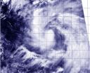
NASA's Aqua satellite passed over newborn Tropical Storm Phanfone on Sept. 29 and captured a picture of the storm that showed thunderstorms wrapped tightly around the storm's center, and a large band of thunderstorms spiraling into the center from the east. Phanfone is now a threat to various islands and warnings are in effect.
A tropical storm Warning is in effect for Saipan, Tinian, Pagan and Alamagan. In addition, a typhoon watch is in effect for the northern Marianas Islands, including Pagan and Alamagan.
The Moderate Resolution Imaging Spectroradiometer (MODIS) ...
NASA sees Tropical Storm Kammuri winding down over open ocean
2014-09-29
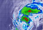
Tropical Storm Kammuri continues to appear more like a cold front on satellite imagery as it transitions into an extra-tropical storm over the Northwestern Pacific Ocean.
When NASA's Terra satellite passed over Kammuri on Sept. 29 at 7:40 a.m. EDT (11:40 UTC), the Moderate Resolution Imaging Spectroradiometer or MODIS instrument captured an infrared look at the storm. MODIS showed that the bulk of strong storms elongated from southwest to northeast.
On Sept. 29, 2014 at 0300 UTC (Sept. 28 at 11 p.m. EDT) Tropical Storm Kammuri had maximum sustained winds near 45 knots ...
NASA's Aqua satellite sees Rachel before losing hurricane status
2014-09-29
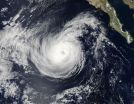
Tropical Storm Rachel strengthened into a hurricane over the weekend of Sept. 27 and 28, only to weaken back into a tropical storm by Sept. 29. NASA's Aqua satellite passed over Rachel before it weakened and took a visible picture of the storm off Baja California's coast.
Rachel became the Eastern Pacific Ocean's twelfth hurricane on Saturday, Sept. 27 at 5 p.m. EDT when maximum sustained winds reached 75 mph (120 kph). When NASA's Aqua satellite saw Rachel, the maximum sustained winds were at the same strength. At that time, Rachel's center was 485 miles (780 km) west ...
MaxBin: Automated sorting through metagenomes

2014-09-29
Microbes – the single-celled organisms that dominate every ecosystem on Earth - have an amazing ability to feed on plant biomass and convert it into other chemical products. Tapping into this talent has the potential to revolutionize energy, medicine, environmental remediation and many other fields. The success of this effort hinges in part on metagenomics, the emerging technology that enables researchers to read all the individual genomes of a sample microbial community at once. However, given that even a teaspoon of soil can contain billions of microbes, there is a great ...
Adding uncertainty to improve mathematical models
2014-09-29
PROVIDENCE, R.I. [Brown University] — Mathematicians from Brown University have introduced a new element of uncertainty into an equation used to describe the behavior of fluid flows. While being as certain as possible is generally the stock and trade of mathematics, the researchers hope this new formulation might ultimately lead to mathematical models that better reflect the inherent uncertainties of the natural world.
The research, published in Proceedings of the Royal Society A, deals with Burgers' equation, which is used to describe turbulence and shocks in fluid flows. ...
New ways to treat anemia could evolve from acetate supplement research

2014-09-29
DALLAS – Sept. 29, 2014 – UT Southwestern Medical Center researchers seeking novel treatments for anemia found that giving acetate, the major component of household vinegar, to anemic mice stimulated the formation of new red blood cells.
Currently, the hormone erythropoietin is administered to treat anemia, but this treatment carries with it side effects such as hypertension and thrombosis (blood clotting). The new research, which was performed in mice, suggests that acetate supplements could eventually be a suitable supplement or possibly even an alternative to administration ...
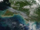
Fires in Papua, Indonesia and New Guinea
2014-09-29
According to a NASA story from 2009, "human activities in this area of the world have contributed to the growing fire emissions issue. Palm oil is increasingly grown for use as a cooking oil and biofuel, while also replacing trans fats in processed foods. It has become the most widely produced edible oil in the world, and production has swelled in recent years to surpass that of soybean oil.
The environmental effects of such growth have been significant. Land has to be cleared to grow the crop, and the preferred method is fire. The clearing often occurs in drained peatlands ...
Modeling shockwaves through the brain
2014-09-29
Since the start of the military conflicts in Iraq and Afghanistan, more than 300,000 soldiers have returned to the United States with traumatic brain injury caused by exposure to bomb blasts — and in particular, exposure to improvised explosive devices, or IEDs. Symptoms of traumatic brain injury can range from the mild, such as lingering headaches and nausea, to more severe impairments in memory and cognition.
Since 2007, the U.S. Department of Defense has recognized the critical importance and complexity of this problem, and has made significant investments in traumatic ...
Self-compassion key to positive body image and coping
2014-09-29
Women who accept and tolerate their imperfections appear to have a more positive body image despite their body mass index (BMI) and are better able to handle personal disappointments and setbacks in their daily lives.
Research out of the Faculty of Arts at the University of Waterloo found that this self-compassion might be an important means to increase positive body image and protect girls and young women against unhealthy weight-control practices and eating disorders.
"Women may experience a more positive body image and better eating habits if they approach disappointments ...
LAST 30 PRESS RELEASES:
Milky Way-like galaxy M83 consumes high-speed clouds
Study: What we learned from record-breaking 2021 heat wave and what we can expect in the future
Transforming treatment outcomes for people with OCD
Damage from smoke and respiratory viruses mitigated in mice via a common signaling pathway
New software tool could help better understand childhood cancer
Healthy lifestyle linked to lower diverticulitis risk, irrespective of genetic susceptibility
Women 65+ still at heightened risk of cervical cancer caused by HPV
‘Inflammatory’ diet during pregnancy may raise child’s diabetes type 1 risk
Effective therapies needed to halt rise in eco-anxiety, says psychology professor
Nature-friendly farming boosts biodiversity and yields but may require new subsidies
Against the odds: Endometriosis linked to four times higher pregnancy rates than other causes of infertility, new study reveals
Microplastics discovered in human reproductive fluids, new study reveals
Family ties and firm performance: How cousin marriage traditions shape informal businesses in Africa
Novel flu vaccine adjuvant improves protection against influenza viruses, study finds
Manipulation of light at the nanoscale helps advance biosensing
New mechanism discovered in ovarian cancer peritoneal metastasis: YWHAB restriction drives stemness and chemoresistance
New study links blood metabolites and immune cells to increased risk of urolithiasis
Pyruvate identified as a promising therapeutic agent for ulcerative colitis by targeting cytosolic phospholipase A2
New insights into the clinical impact of IKBKG mutations: Understanding the mechanisms behind rare immunodeficiency syndromes
Displays, imaging and sensing: New blue fluorophore breaks efficiency records in both solids and solutions
Sugar, the hidden thermostat in plants
Personality can explain why some CEOs earn higher salaries
This puzzle game shows kids how they’re smarter than AI
Study suggests remembrances of dead played role in rise of architecture in Andean region
Brain stimulation can boost math learning in people with weaker neural connections
Inhibiting enzyme could halt cell death in Parkinson’s disease, study finds
Neurotechnology reverses biological disadvantage in maths learning
UNDER EMBARGO: Neurotechnology reverses biological disadvantage in maths learning
Scientists target ‘molecular machine’ in the war against antimicrobial resistance
Extending classical CNOP method for deep-learning atmospheric and oceanic forecasting
[Press-News.org] Glaciers in the Grand Canyon of Mars?New Geology articles posted online ahead of print on Sept. 26, 2014