NOAA's GOES-West satellite sees smoke from Canadian fires over US
Published 2014-07-10 · Original archive entry · Explore research explainers
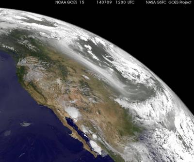
NOAA's Geostationary Operational Environmental Satellite or GOES-West satellite spotted smoke over the U.S. Mid-West from dozens of fires raging in Canada's Northwestern Territories.
At 1200 UTC (8 a.m. EDT) on July 9, 2014, GOES-West captured this image of the brownish-colored haze created by forest fires in Canada's Northwest Territories that drifted all the way into South Dakota. This image was created by the NASA GOES Project at NASA Goddard Space Flight Center, Greenbelt, Md.
According to Canada's Natural Resources, Canadian Wildland Fire Information System, fire danger remains high throughout much of Canada. Fire danger is very high in British Columbia, Alberta and northern Saskatchewan. In the Northwest Territories smoke is an issue at the South Slave: Hay River District, where evacuation orders are in effect for some communities.
There are several Wildland Fire Bulletins in effect for July 10, 2014 in the Northwestern Territories, including: Deh Cho Region, Inuvik Region, North Slave Region, Sahtu Region, South Slave: Fort Smith District and South Slave: Hay River District. For more information the located of the Canadian fires, visit: http://cwfis.cfs.nrcan.gc.ca/interactive-map.
INFORMATION:
At 1200 UTC (8 a.m. EDT) on July 9, 2014, GOES-West captured this image of the brownish-colored haze created by forest fires in Canada's Northwest Territories that drifted all the way into South Dakota. This image was created by the NASA GOES Project at NASA Goddard Space Flight Center, Greenbelt, Md.
According to Canada's Natural Resources, Canadian Wildland Fire Information System, fire danger remains high throughout much of Canada. Fire danger is very high in British Columbia, Alberta and northern Saskatchewan. In the Northwest Territories smoke is an issue at the South Slave: Hay River District, where evacuation orders are in effect for some communities.
There are several Wildland Fire Bulletins in effect for July 10, 2014 in the Northwestern Territories, including: Deh Cho Region, Inuvik Region, North Slave Region, Sahtu Region, South Slave: Fort Smith District and South Slave: Hay River District. For more information the located of the Canadian fires, visit: http://cwfis.cfs.nrcan.gc.ca/interactive-map.
INFORMATION: