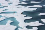
(Press-News.org) Sea ice in summer looks dramatically different than sea ice in winter, even in the polar Arctic. Summer snowmelt, pools of water on thinning ice and exposed ocean replace vast winter expanses of white snow-covered ice – and this weekend NASA's high-flying laser altimeter begins a campaign to investigate these features.
Icy areas look different from a satellite's perspective as well. When NASA launches the Ice, Cloud and land Elevation Satellite-2, or ICESat-2, in 2017, it will measure Earth's elevation by sending out pulses of green laser light and timing how long it takes individual photons to bounce off Earth's surface and return. The number and patterns of photons that come back depend on the type of ice they bounce off – whether it's smooth or rough, watery or snow-covered.
To get a preview of what summertime will look like to ICESat-2, NASA scientists, engineers and pilots have travelled to Fairbanks, Alaska, to fly an airborne test bed instrument called the Multiple Altimeter Beam Experimental Lidar, or MABEL. MABEL collects data in the same way that ICESat-2's instrument will – with lasers and photon-detectors. So the data from the Alaskan campaign will allow researchers to develop computer programs, or algorithms, to analyze the information from ICESat-2.
"We need to give scientists data to enable them to develop algorithms that work during summer," said Thorsten Markus, ICESat-2's project scientist at NASA's Goddard Space Flight Center in Greenbelt, Maryland. "All the algorithms need to be tested and in place by the time of launch. And one thing that was missing was ICESat-2-like data on the summer conditions."
Between July 12 and August 1, MABEL will fly aboard NASA's high-altitude ER-2 aircraft as the Arctic sea ice and glaciers are melting. In its half-dozen flights, the instrument will take measurements of the sea ice and Alaska's southern glaciers, as well as forests, lakes, open ocean, the atmosphere and more, sending data back to researchers on the ground.
A key element of the campaign, however, is to fly over melt ponds – areas where snow has melted, pooling up in low spots of the sea ice or glaciers – and bare ice with no snow coverage to find out how to identify and study these features with ICESat-2-like data.
Scientists have many questions about melt ponds, and their impact on the extent of summer ice melt. Dark water absorbs much more heat from the sun than bright, reflective ice and snow, so when a pool of liquid water forms on top of ice, it changes the heat balance. The water warms up in the summer sun, and can speed up melting of the surrounding ice, possibly influencing the Arctic Ocean's sea ice minimum extent.
"The melt pond coverage may be an indicator of the ice coverage at the end of the summer," said Ron Kwok, a senior research scientist at NASA's Jet Propulsion Laboratory in Pasadena, California. "But we don't have a lot of information about melt pond coverage over the Arctic."
Although scientists know the ponds are present, and cover a lot of area, they don't know how the number, size and depth vary from year to year, and region to region, said Kwok, also a member of the ICESat-2 Science Definition Team who is developing sea ice algorithms.
Melt ponds can also tell researchers about the sea ice itself, Kwok said. Deeper, smaller ponds can form on the bumpy and ridged older ice, which has withstood multiple years in the Arctic Ocean. Newer ice – ice that formed the winter before – hasn't had the time to build up ridges, and so would be flat and covered with large shallow ponds.
"In the summer, we can tell whether it's first year ice or older, based roughly on the shape and size of the melt ponds," Kwok said.
The MABEL flights will allow researchers to determine what those ponds and melting snow will look like from ICESat-2, and how to best analyze the returning photons. The ponds could be tricky to study, he said, since some photons might reflect off the surface, while others could make it through the water to bounce off the bottom of the pond.
"We have to design the algorithms to adapt to what we're learning this summer," Kwok said. "We don't have any preconceived notions as to what we might see, and that's why it's so important to fly MABEL."
The flight plans for the ER-2 carrying MABEL involve a route that would take it north, possibly over the North Pole, to look at a variety of sea ice conditions, as well as some ice fields north of Fairbanks, said Bill Cook, MABEL's lead scientist. The aircraft will also fly above forests, along some of the same paths of another NASA campaign that is flying Goddard's LiDAR, Hyperspectral and Thermal Imager, or G-LiHT, just above the treetops. Researchers will be able to then compare the data from MABEL and G-LiHT, Cook noted.
With 48 hours of flying time available, he said, the first priority are the flights north toward the pole to see how different the summer ice looks to MABEL.
INFORMATION:
Follow NASA campaigns blogging from Alaska this summer at:
http://earthobservatory.nasa.gov/blogs/fromthefield/
For more information on ICESat-2, visit:
http://icesat.gsfc.nasa.gov/icesat2/
For more information on G-LiHT, visit:
http://gliht.gsfc.nasa.gov/
NASA's high-flying laser altimeter to check out summer sea ice and more
2014-07-11
ELSE PRESS RELEASES FROM THIS DATE:
Out of an hours-long explosion, a stand-in for the first stars
2014-07-11
Astronomers analyzing a long-lasting blast of high-energy light observed in 2013 report finding features strikingly similar to those expected from an explosion from the universe's earliest stars. If this interpretation is correct, the outburst validates ideas about a recently identified class of gamma-ray burst and serves as a stand-in for what future observatories may see as the last acts of the first stars.
"One of the great challenges of modern astrophysics has been the quest to identify the first generation of stars to form in the universe, which we refer to as Population ...
AgriLife Research study identifies contributing factors to groundwater table declines
2014-07-11
VERNON – It's no secret groundwater levels have declined across the state over the past eight decades, and that the primary reason was the onset of irrigation in agriculture and population growth. But a recent Texas A&M AgriLife Research study has identified other factors having an impact.
The groundwater declines have been most severe in the past four decades, but the news isn't all bad, according to Dr. Srinivasulu Ale, AgriLife Research geospatial hydrology assistant professor in Vernon.
"Long-term (1930�) trends in groundwater levels in Texas: Influences ...
USC Stem Cell scientists lay a TRAP for disease
2014-07-11
USC Stem Cell scientists have set a "mouse TRAP" to capture the early signs of kidney failure, as described by a recent study published in the Journal of Clinical Investigation. Their new transgenic mouse line uses a technique called TRAP to extract cellular and genetic information from a variety of solid organs.
Invented by scientists at the Rockefeller Institute for Medical Research in 2008, TRAP involves attaching a fluorescent tag to the protein-making machinery, or ribosomes, of the cell type of interest. Scientists can then collect the tagged ribosomes and determine ...
Major study documents nutritional and food safety benefits of organic farming
2014-07-11
PULLMAN, Wash.—The largest study of its kind has found that organic foods and crops have a suite of advantages over their conventional counterparts, including more antioxidants and fewer, less frequent pesticide residues.
The study looked at an unprecedented 343 peer-reviewed publications comparing the nutritional quality and safety of organic and conventional plant-based foods, including fruits, vegetables, and grains. The study team applied sophisticated meta-analysis techniques to quantify differences between organic and non-organic foods.
"Science marches on," said ...
NMR under pressure: Reproducing deep-Earth chemistry
2014-07-11
VIDEO:
Chemists want to understand chemical reactions that happen in solutions under high pressure in the Earth's crust. A new device invented at UC Davis allows chemists to make nuclear magnetic...
Click here for more information.
A new pressure cell invented by UC Davis researchers makes it possible to simulate chemical reactions deep in the Earth's crust. The cell allows researchers to perform nuclear magnetic resonance (NMR) measurements on as little as 10 microliters ...
Miriam Hospital study examines smoking prevalence
2014-07-11
PROVIDENCE, R.I. -- Researchers from The Miriam Hospital have found that people with mobility impairments under age 65 have significantly higher rates of smoking than those without mobility impairments. Additionally, smokers with mobility impairments were less likely to attempt quitting than those without mobility impairments, and evidence-based, quit-smoking treatments may not be sufficient for this population. The study and its findings are published online in advance of print in the American Journal of Public Health.
Lead researcher Belinda Borrelli, Ph.D., of The ...
Obese US firefighters report receiving no weight advice from their health provider
2014-07-11
HOUSTON – (July 10, 2014) – Obese and overweight firefighters are not receiving weight management advice from their health care providers, according to new research from The University of Texas Health Science Center at Houston (UTHealth).
National guidelines state that health care professionals (HCPs) should advise patients on the importance of maintaining a healthy weight. Firefighters have high rates of obesity, and cardiovascular events are the leading cause of line-of-duty deaths in firefighters. This study assessed the association of age and body mass index (BMI) ...
Many fires in New South Wales, Australia
2014-07-11
There were many fires burning in eastern New South Wales, Australia when NASA's Aqua satellite passed overhead on July 11.
At 03:35 UTC on July 11 (12:35 p.m. local time/11:35 p.m. EDT on July 10), when Aqua passed over eastern New South Wales (NSW), the Moderate Resolution Imaging Spectroradiometer (MODIS) aboard captured a natural-color visible image of the region and spotted smoke (light brown) from various fires. Actively burning areas, detected by MODIS's thermal bands, are outlined in red.
The New South Wales, Australia Government website "NSW Rural Fire Service" ...
Mills Canyon fire, Washington
2014-07-11
The Mills Canyon fire started near the City of Entiat on Tuesday, July 8, 2014. Despite the efforts of local resources, the fire quickly grew to over 1,000 acres by evening. Three outbuildings were damaged. The cause of the fire is under investigation by the Washington Department of Natural Resources. The fire team is working with existing local resources in developing fire control strategies and tactics. Other cooperators include the U.S. Forest Service (USFS), Washington State Department of Natural Resources, (WA DNR), Bureau of Land Management, Chelan County Emergency ...
New simple setup for X-ray phase contrast
2014-07-11
This news release is available in German. X-ray phase-contrast imaging is a method that uses the refraction of X-rays through a specimen instead of attenuation resulting from absorption. The images produced with this method are often of much higher quality than those based on absorption. The scientists in the team of Prof. Franz Pfeiffer are particularly interested in developing new approaches for biomedical X-ray imaging and therapy – including X-ray phase-contrast imaging. One main goal is to make this method available for clinical applications such as diagnosis of ...


