NASA sees Cyclone Hudhud approaching India's coast
Published 2014-10-14 · Original archive entry · Explore research explainers
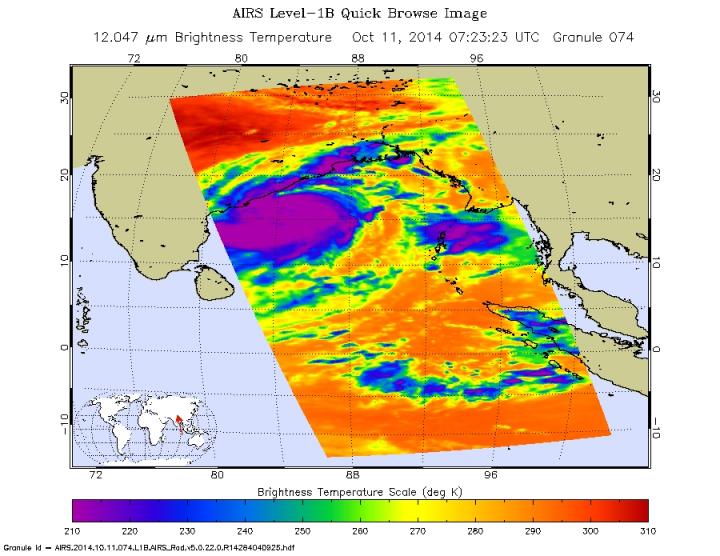
NASA's Aqua satellite passed over Cyclone Hudhud as it was nearing east-central India's coastline on Oct. 11.
The Atmospheric Infrared Sounder or AIRS instrument aboard Aqua captured infrared data on the storm on Oct. 11 at 07:23 UTC (3:23 a.m. EDT) that showed cloud top temperatures had dropped, indicating stronger uplift and stronger thunderstorms. That's an indication that the storm has strengthened in the last day.
The Joint Typhoon Warning Center noted that animated infrared satellite imagery shows the eye feature has become cloud filled while the overall structure of the system has remained unchanged while remaining symmetric (rounded) and with bands of thunderstorms wrapping into the center. Radar imagery from Visakhapatnam shows the system has remained tightly wrapped and reveals a defined eye feature.
On Oct. 11 at 2100 UTC (5 p.m. EDT), Cyclone Hudhud's maximum sustained winds increased to 110 knots (75 mph/120 kph), which classifies as a typhoon on the Saffir-Simpson scale. It was centered near 16.8 north and 80.9 east, about 102 nautical miles East of Visakhapatnam, India. Hudhud was moving to the northwestward at 4 knots.
Hudhud is forecast to continue intensifying prior to landfall under good environmental conditions and should peak near 115 knots and weaken quickly. Hudhud is expected to dissipate on Monday, Oct. 13 over land.
INFORMATION: Rob Gutro
NASA's Goddard Space Flight Center
The Atmospheric Infrared Sounder or AIRS instrument aboard Aqua captured infrared data on the storm on Oct. 11 at 07:23 UTC (3:23 a.m. EDT) that showed cloud top temperatures had dropped, indicating stronger uplift and stronger thunderstorms. That's an indication that the storm has strengthened in the last day.
The Joint Typhoon Warning Center noted that animated infrared satellite imagery shows the eye feature has become cloud filled while the overall structure of the system has remained unchanged while remaining symmetric (rounded) and with bands of thunderstorms wrapping into the center. Radar imagery from Visakhapatnam shows the system has remained tightly wrapped and reveals a defined eye feature.
On Oct. 11 at 2100 UTC (5 p.m. EDT), Cyclone Hudhud's maximum sustained winds increased to 110 knots (75 mph/120 kph), which classifies as a typhoon on the Saffir-Simpson scale. It was centered near 16.8 north and 80.9 east, about 102 nautical miles East of Visakhapatnam, India. Hudhud was moving to the northwestward at 4 knots.
Hudhud is forecast to continue intensifying prior to landfall under good environmental conditions and should peak near 115 knots and weaken quickly. Hudhud is expected to dissipate on Monday, Oct. 13 over land.
INFORMATION: Rob Gutro
NASA's Goddard Space Flight Center