RapidScat eyes Ex-Tropical Cyclone Pam's winds near Chatham Islands
Published 2015-03-17 · Original archive entry · Explore research explainers
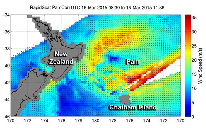
The New Zealand Meteorological Service issued a Storm Warning for the Chatham Islands today as NASA's RapidScat instrument found that winds in one quadrant of Ex-Tropical Cyclone Pam is still generating tropical-storm-force winds east of its center.
The International Space Station's RapidScat instrument captured data on Ex-Tropical Cyclone Pam's winds on March 16 from 08:30 to 11:36 UTC. RapidScat revealed sustained winds over 30 meters per second (108 kph/67 mph) were still occurring southeast of the center.
The forecast calls for southwesterly winds to 50 knots (57 mph/92 kph) with high seas easing. The "easterly swell 4 meters and southwest swell rising to 7 meters. Poor visibility in heavy rain at times.
On March 17 (or 12:17 a.m. local time, March 18), the New Zealand Meteorlogical Service bulletin stated "Ex Tropical Cyclone Pam lies southeast of the Chatham Islands today, leaving a south to southwest flow over New Zealand. A ridge moves onto New Zealand on Thursday." For updated forecasts,visit: http://www.metservice.com/marine-surf/coastal/chatham-islands
The International Space Station's RapidScat instrument captured data on Ex-Tropical Cyclone Pam's winds on March 16 from 08:30 to 11:36 UTC. RapidScat revealed sustained winds over 30 meters per second (108 kph/67 mph) were still occurring southeast of the center.
The forecast calls for southwesterly winds to 50 knots (57 mph/92 kph) with high seas easing. The "easterly swell 4 meters and southwest swell rising to 7 meters. Poor visibility in heavy rain at times.
On March 17 (or 12:17 a.m. local time, March 18), the New Zealand Meteorlogical Service bulletin stated "Ex Tropical Cyclone Pam lies southeast of the Chatham Islands today, leaving a south to southwest flow over New Zealand. A ridge moves onto New Zealand on Thursday." For updated forecasts,visit: http://www.metservice.com/marine-surf/coastal/chatham-islands
INFORMATION: