GOES satellite sees a triple header in the tropics
System 99L looks ripe for development in the Atlantic
Published 2011-07-22 · Original archive entry · Explore research explainers
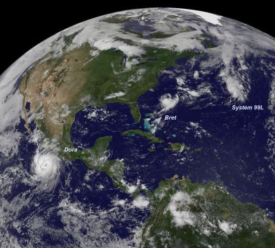
The GOES-13 satellite captured a triple-header in the tropics today when it captured three tropical cyclones in one image in the Northern Hemisphere.
A visible image taken from the GOES-13 satellite on July 20 at 14:45 UTC (10:45 a.m. EDT) and shows a consolidating low pressure area called System 99L in the eastern North Atlantic Ocean, Tropical Storm Bret several hundred miles east of South Carolina, and a large Hurricane Dora off the west coast of Mexico. The image was created by the NASA/NOAA GOES Project at NASA's Goddard Space Flight Center in Greenbelt, Md.
System 99L is a low pressure area that may to reach tropical depression status in the next day or two. It is located about 550 miles east-northeast of Bermuda and is moving to the northeast at 20 mph.
At 2 p.m. EDT on July 20, satellite imagery showed that showers and thunderstorms have become better organized within System 99L. The low-level circulation is also becoming better defined and the storm appears primed to become a tropical depression. If that happens, it would be Tropical Depression 3 (TD3) in the Atlantic Ocean basin. The National Hurricane Center gives it a 90 percent chance of coming together as TD3 in the next 48 hours.
INFORMATION:
NASA's Hurricane page: www.nasa.gov/hurricane, also on Facebook and Twitter
A visible image taken from the GOES-13 satellite on July 20 at 14:45 UTC (10:45 a.m. EDT) and shows a consolidating low pressure area called System 99L in the eastern North Atlantic Ocean, Tropical Storm Bret several hundred miles east of South Carolina, and a large Hurricane Dora off the west coast of Mexico. The image was created by the NASA/NOAA GOES Project at NASA's Goddard Space Flight Center in Greenbelt, Md.
System 99L is a low pressure area that may to reach tropical depression status in the next day or two. It is located about 550 miles east-northeast of Bermuda and is moving to the northeast at 20 mph.
At 2 p.m. EDT on July 20, satellite imagery showed that showers and thunderstorms have become better organized within System 99L. The low-level circulation is also becoming better defined and the storm appears primed to become a tropical depression. If that happens, it would be Tropical Depression 3 (TD3) in the Atlantic Ocean basin. The National Hurricane Center gives it a 90 percent chance of coming together as TD3 in the next 48 hours.
INFORMATION:
NASA's Hurricane page: www.nasa.gov/hurricane, also on Facebook and Twitter