NASA sees strong wind shear adversely affect Tropical Storm Maria
Published 2012-10-19 · Original archive entry · Explore research explainers
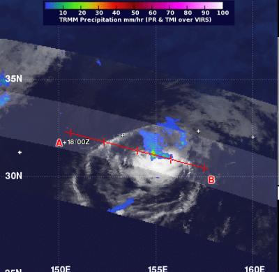
Tropical Storm Maria is moving away from Japan and strong wind shear is pushing its rainfall east of the storm's center, according to NASA satellite imagery.
On Oct. 18 at 0845 UTC (4:45 a.m. EDT), NASA's Tropical Rainfall Measuring Mission (TRMM) satellite saw that rain associated with Tropical Storm Maria was limited to the east of the storm's center. Rainfall was also light to moderate, falling at a rate between .78 to 1.57 inches/20 to 40 mm per hour. There were no areas of heavy rain remaining in the tropical cyclone. The low-level center of the storm is now exposed and a wind shear greater than 30 knots (34.5 mph/55.5 kph) continues to further weaken the storm.
At 1500 UTC (11 a.m. EDT) on Oct 18, Maria's maximum sustained winds were down to 35 knots (~40 mph/65 kph) and weakening. It was located near 31.9 North and 155.6 East, about 780 nautical miles east of Tokyo, Japan. It was moving to the east and into the open waters of the northern Pacific at a speed of 14 knots (16 mph/26 kph).
By Oct. 19, the combination of the strong wind shear with cooler sea surface temperatures are expected to make Maria dissipate.
INFORMATION:
On Oct. 18 at 0845 UTC (4:45 a.m. EDT), NASA's Tropical Rainfall Measuring Mission (TRMM) satellite saw that rain associated with Tropical Storm Maria was limited to the east of the storm's center. Rainfall was also light to moderate, falling at a rate between .78 to 1.57 inches/20 to 40 mm per hour. There were no areas of heavy rain remaining in the tropical cyclone. The low-level center of the storm is now exposed and a wind shear greater than 30 knots (34.5 mph/55.5 kph) continues to further weaken the storm.
At 1500 UTC (11 a.m. EDT) on Oct 18, Maria's maximum sustained winds were down to 35 knots (~40 mph/65 kph) and weakening. It was located near 31.9 North and 155.6 East, about 780 nautical miles east of Tokyo, Japan. It was moving to the east and into the open waters of the northern Pacific at a speed of 14 knots (16 mph/26 kph).
By Oct. 19, the combination of the strong wind shear with cooler sea surface temperatures are expected to make Maria dissipate.
INFORMATION: