NASA's Aqua satellite spots Central Pacific's Tropical Storm Ana
Published 2014-10-14 · Original archive entry · Explore research explainers
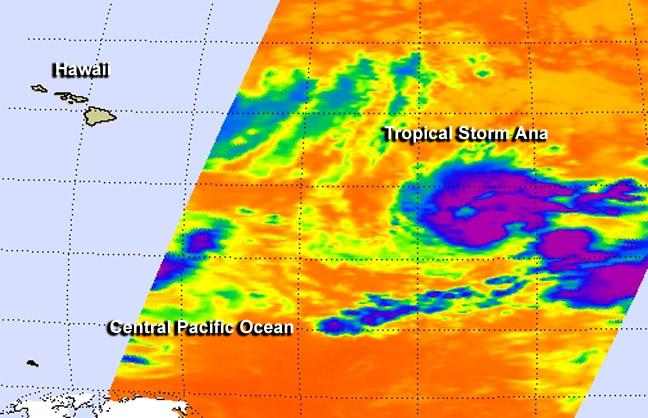
NASA's Aqua satellite passed over Tropical Storm Ana on Monday, Oct. 13 after it formed in the Central Pacific Ocean.
Ana formed on Oct. 13 at 5 p.m. EDT (11 a.m. HST) as Tropical Depression 2-C, about 920 miles (1,480 km) east-southeast of Hilo, Hawaii. By 9 p.m. EDT that day, the depression had strengthened into Tropical Depression Ana.
NASA's Aqua satellite passed over Tropical Storm Ana on Monday, Oct. 13 at 11:11 UTC (7:11 a.m. EDT) and the Atmospheric Infrared Sounder or AIRS instrument gathered infrared data that showed some strong thunderstorms and cold cloud tops had developed around the center of circulation.
At 500 am HST, 1500 UTC, Ana's maximum sustained winds were near 50 mph (85 kph) and gradual strengthening is expected through early Thursday morning. The center of Tropical Storm Ana was located near latitude 13.4 north, longitude 143.3 west. That's about 895 miles (1,440 km) east-southeast of Hilo Hawaii. Ana is moving toward the northwest near 5 mph (7 kph) and this motion is expected to continue through early Thursday morning. The estimated minimum central pressure is 1000 millibars.
Currently, NOAA's Central Pacific Hurricane Center has no watches or warnings in effect. However, Ana is forecast to move to the west-northwest and strengthen into a hurricane over the next couple of days, approaching the big island of Hawaii by Sunday, Oct. 19. For updated forecasts, visit: http://www.prh.noaa.gov.
INFORMATION: Rob Gutro
NASA's Goddard Space Flight Center
Ana formed on Oct. 13 at 5 p.m. EDT (11 a.m. HST) as Tropical Depression 2-C, about 920 miles (1,480 km) east-southeast of Hilo, Hawaii. By 9 p.m. EDT that day, the depression had strengthened into Tropical Depression Ana.
NASA's Aqua satellite passed over Tropical Storm Ana on Monday, Oct. 13 at 11:11 UTC (7:11 a.m. EDT) and the Atmospheric Infrared Sounder or AIRS instrument gathered infrared data that showed some strong thunderstorms and cold cloud tops had developed around the center of circulation.
At 500 am HST, 1500 UTC, Ana's maximum sustained winds were near 50 mph (85 kph) and gradual strengthening is expected through early Thursday morning. The center of Tropical Storm Ana was located near latitude 13.4 north, longitude 143.3 west. That's about 895 miles (1,440 km) east-southeast of Hilo Hawaii. Ana is moving toward the northwest near 5 mph (7 kph) and this motion is expected to continue through early Thursday morning. The estimated minimum central pressure is 1000 millibars.
Currently, NOAA's Central Pacific Hurricane Center has no watches or warnings in effect. However, Ana is forecast to move to the west-northwest and strengthen into a hurricane over the next couple of days, approaching the big island of Hawaii by Sunday, Oct. 19. For updated forecasts, visit: http://www.prh.noaa.gov.
INFORMATION: Rob Gutro
NASA's Goddard Space Flight Center