Landsat satellites track continued Missouri River flooding
Published 2011-07-22 · Original archive entry · Explore research explainers
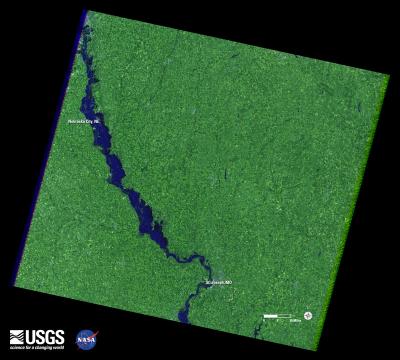
Flooding along the Missouri River continues as shown in recent Landsat satellite images of the Nebraska and Iowa border. Heavy rains and snowmelt have caused the river to remain above flood stage for an extended period.
A Landsat 5 image of the area from May 5, 2011 shows normal flow. In contrast, a Landsat 7 image from July 17 depicts flood conditions in the same location.
A national overview map of streamflow provided by U.S. Geological Survey (USGS) WaterWatch graphically portrays the immense geographic extent of flooding in the Missouri River basin.
Monitoring both floods and droughts, the USGS WaterWatch internet site displays maps, graphs, and tables that describe current and past streamflow conditions for the United States. The real-time streamflow data is generally updated on an hourly basis.
The Landsat Program is a series of Earth-observing satellite missions jointly managed by NASA and the U.S. Geological Survey. Landsat satellites have been consistently gathering data about our planet since 1972. They continue to improve and expand this unparalleled record of Earth's changing landscapes, for the benefit of all. The next Landsat satellite is scheduled to launch in December 2012.
INFORMATION:
For the USGS WaterWatch website, please visit: http://waterwatch.usgs.gov/new/index.php?id=ww
For more information about the Landsat launching in 2012: http://ldcm.gsfc.nasa.gov
A Landsat 5 image of the area from May 5, 2011 shows normal flow. In contrast, a Landsat 7 image from July 17 depicts flood conditions in the same location.
A national overview map of streamflow provided by U.S. Geological Survey (USGS) WaterWatch graphically portrays the immense geographic extent of flooding in the Missouri River basin.
Monitoring both floods and droughts, the USGS WaterWatch internet site displays maps, graphs, and tables that describe current and past streamflow conditions for the United States. The real-time streamflow data is generally updated on an hourly basis.
The Landsat Program is a series of Earth-observing satellite missions jointly managed by NASA and the U.S. Geological Survey. Landsat satellites have been consistently gathering data about our planet since 1972. They continue to improve and expand this unparalleled record of Earth's changing landscapes, for the benefit of all. The next Landsat satellite is scheduled to launch in December 2012.
INFORMATION:
For the USGS WaterWatch website, please visit: http://waterwatch.usgs.gov/new/index.php?id=ww
For more information about the Landsat launching in 2012: http://ldcm.gsfc.nasa.gov