(Press-News.org) NASA is carrying out its sixth consecutive year of Operation IceBridge research flights over Antarctica to study changes in the continent's ice sheet, glaciers and sea ice. This year's airborne campaign, which began its first flight Thursday morning, will revisit a section of the Antarctic ice sheet that recently was found to be in irreversible decline.
For the next several weeks, researchers will fly aboard NASA's DC-8 research aircraft out of Punta Arenas, Chile. This year also marks the return to western Antarctica following 2013's campaign based at the National Science Foundation's McMurdo Station.
"We are curious to see how much these glaciers have changed in two years," said Eric Rignot, IceBridge science team co-lead and glaciologist at the University of California, Irvine and NASA's Jet Propulsion Laboratory (JPL) in Pasadena, California.
IceBridge will use a suite of instruments that includes a laser altimeter, radar instruments, cameras, and a gravimeter, which is an instrument that detects small changes in gravity. These small changes reveal how much mass these glaciers have lost. Repeated annual measurements of key glaciers maintains a long-term record of change in the Antarctic that goes back to NASA's Ice, Cloud and Land Elevation Satellite (ICESat) which stopped collecting data in 2009.
IceBridge researchers plan to measure previously unsurveyed regions of Antarctica. One example is a plan to look at the upper portions of Smith Glacier in West Antarctica, which is thinning faster than any other glaciers in the region. The mission also plans to collect data in portions of the Antarctic Peninsula, such as the Larsen C, George VI and Wilkins ice shelves and the glaciers that drain into them. The Antarctic Peninsula has been warming faster than the rest of the continent.
"The Antarctic Peninsula is changing fairly rapidly and we need to be there to capture that change," said Michael Studinger, IceBridge project scientist at NASA's Goddard Space Flight Center in Greenbelt, Maryland.
The mission also will collect data on Antarctic sea ice, which recently reached a record high coverage. This contrasts with declining sea ice in the Arctic and is due do a variety of factors such as changing wind patterns. Antarctic sea ice coverage is slightly above average and the growth varies from one part of Antarctica to another. For example, ice cover in the Bellingshausen Sea has been decreasing while ice in the nearby Ross Sea is growing.
"There are very strong regional variations on how sea ice is changing," said Nathan Kurtz, a sea ice scientist at Goddard. These regional trends together yield a small increase, so studying each region will help scientists get a better grasp on the processes affecting sea ice there.
In addition to extending ICESat's data record over land and sea ice, IceBridge will also help set the stage for ICESat-2 by measuring ice the satellite will fly over. One of IceBridge's highest priority surveys is a circular flight the DC-8 will fly around the South Pole at 88 degrees south latitude. This latitude line is where all of ICESat-2's orbits will converge in the Southern Hemisphere. Measuring ice elevation at these locations will help researchers build a time series of data that spans more than a decade and provide a way to help verify ICESat-2's data.
IceBridge's Antarctic field campaign will run through late November. The IceBridge project science office is based at Goddard. The DC-8 research aircraft is based at NASA's Armstrong Flight Research Center's facility in Palmdale, California.
INFORMATION:
For more about Operation IceBridge, visit:
http://www.nasa.gov/icebridge
NASA monitors Earth's vital signs from land, air and space with a fleet of satellites and ambitious airborne and ground-based observation campaigns. NASA develops new ways to observe and study Earth's interconnected natural systems with long-term data records and computer analysis tools to better see how our planet is changing. The agency shares this unique knowledge with the global community and works with institutions in the United States and around the world that contribute to understanding and protecting our home planet.
For more information about NASA's recent Earth science activities, visit:
http://www.nasa.gov/earthrightnow
NASA's Interface Region Imaging Spectrograph (IRIS) has provided scientists with five new findings into how the sun's atmosphere, or corona, is heated far hotter than its surface, what causes the sun's constant outflow of particles called the solar wind, and what mechanisms accelerate particles that power solar flares.
The new information will help researchers better understand how our nearest star transfers energy through its atmosphere and track the dynamic solar activity that can impact technological infrastructure in space and on Earth. Details of the findings appear ...
Parasitic bacteria were the first cousins of the mitochondria that power cells in animals and plants – and first acted as energy parasites in those cells before becoming beneficial, according to a new University of Virginia study that used next-generation DNA sequencing technologies to decode the genomes of 18 bacteria that are close relatives of mitochondria.
The study appears this week in the online journal PLOS One, published by the Public Library of Science. It provides an alternative theory to two current theories of how simple bacterial cells were swallowed ...
The need for food, animal feed and fuel in the Sahel belt is growing year on year, but supply is not increasing at the same rate. New figures from 22 countries indicate falling availability of resources per capita and a continued risk of famine in areas with low 'primary production' from plants. Rising temperatures present an alarming prospect, according to a study from Lund University in Sweden.
The research has investigated developments between the years 2000 and 2010 in the Sahel belt, south of the Sahara Desert. Over this ten-year period, the population of the region ...
Cold Spring Harbor, NY – How many times have we seen Superman swoop down from the heavens and rescue a would-be victim from a rapidly oncoming train?
It's a familiar scenario, played out hundreds of times in the movies. But the dramatic scene is reenacted in real life every time a cell divides. In order for division to occur, our genetic material must be faithfully replicated by a highly complicated machine, whose parts are tiny enough to navigate among the strands of the double helix.
The problem is that our DNA is constantly in use, with other molecular machines ...
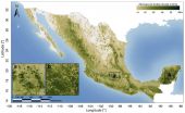
Available for download today, the Woods Hole Research Center (WHRC) and Allianza MREDD+ released the first detailed map of aboveground forest carbon stocks of Mexico. This carbon stock inventory is very valuable for Mexico, as one of the first tropical nations to voluntarily pledge to mitigation actions within the context of the United Nation's Reducing Emissions from Deforestation and forest Degradation (REDD+) program.
The hectare-scale map is the result of a collaboration led by WHRC scientists Josef Kellndorfer and Oliver Cartus with Mexico's National Forestry Commission ...
1. Conventional medical centers may be unable to prevent spread of Ebola
A group of infectious disease experts suggests that conventional U.S. medical centers are unprepared and ill equipped to manage Ebola and a national network of specialized containment and treatment facilities may be needed to reduce the virus' spread, according to an article being published in Annals of Internal Medicine. Despite efforts from the Centers for Disease Control and Prevention (CDC) to prepare hospitals for Ebola, enormous challenges remain. The authors express doubt that conventional ...
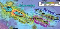
A UC Santa Barbara geochemist studying Samoan volcanoes has found evidence of the planet's early formation still trapped inside the Earth. Known as hotspots, volcanic island chains such as Samoa can ancient primordial signatures from the early solar system that have somehow survived billions of years.
Matthew Jackson, an associate professor in UCSB's Department of Earth Science, and colleagues utilized high-precision lead and helium isotope measurements to unravel the chemical composition and geometry of the deep mantle plume feeding Samoa's volcanoes. Their findings ...
VIDEO:
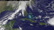
NOAA's GOES-East satellite captured this image of Hurricane Gonzalo off the U.S. East Coast on Oct. 16 at 13:07 UTC (9:07 a.m. EDT).
Click here for more information.
NASA and NOAA satellites have been providing continuous coverage of Hurricane Gonzalo as it moves toward Bermuda. NASA's Terra satellite saw thunderstorms wrapped tightly around the center with large bands of thunderstorms wrapping into it. NOAA's GOES-East satellite provided and "eye-opening" view of Gonzalo, ...
Tropical Storm Ana continued on a path to the Hawaiian Islands as NASA's Terra satellite passed overhead and gathered data on the storm. NOAA's GOES-West satellite data was compiled into a movie that showed the intensification and movement of Ana. Watches are now in effect for Hawaii.
NOAA's Central Pacific Hurricane Center (CPHC) has issued a Tropical Storm Watch for Hawaii County, Hawaii. A tropical storm watch means that tropical storm conditions are possible within the watch area, in this case within 36 to 48 hours. Life-threatening surf and riptide conditions will ...
An international team of scientists has succeeded in explaining the formation and propagation over astronomical distances of jets of matter emitted by young stars—one of the most fascinating mysteries of modern astronomy. Using a patented experimental device and large-scale numerical simulations, the team obtained data consistent with astrophysical observations. The results of this research—just published in the prestigious journal Science—open up new opportunities for studying the role of magnetic fields in astrophysics and thermonuclear fusion. Bruno ...


