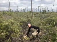
(Press-News.org) DURHAM, N.C. -- Emily Ury remembers the first time she saw them. She was heading east from Columbia, North Carolina, on the flat, low-lying stretch of U.S. Highway 64 toward the Outer Banks. Sticking out of the marsh on one side of the road were not one but hundreds dead trees and stumps, the relic of a once-healthy forest that had been overrun by the inland creep of seawater.
"I was like, 'Whoa.' No leaves; no branches. The trees were literally just trunks. As far as the eye could see," said Ury, who recently earned a biology Ph.D. at Duke University working with professors Emily Bernhardt and Justin Wright.
In bottomlands throughout the U.S. East Coast, trees are dying off as rising seas and higher storm surges push saltwater farther inland, poisoning soils far from shore.
While these "ghost forests" are becoming a more common sight in North Carolina's coastal plain, scientists had only a rough idea of their extent. Now, satellite images are providing new answers.
In a study published April 4 in the journal Ecological Applications, a Duke-led team mined 35 years of satellite images of a 245,000-acre area in the state's Albemarle-Pamlico Peninsula.
The images show that, between 1985 and 2019, 11% of the area's tree cover was taken over by ghost forests. Instead of mirroring the gradual pace of sea level rise, most of this spread occurred abruptly in the wake of extreme weather events such as hurricanes and droughts, which can concentrate salts or send them surging into the region's interior.
The study focused on the Alligator River National Wildlife Refuge, which was established in 1984 to protect the area's unique forested wetlands and the endangered red wolves, red-cockaded woodpeckers and other wildlife that live there.
Here, the Duke team is monitoring what Bernhardt and other researchers call "the leading edge of climate change."
From 1900 to 2000, the sea rose about a foot in this part of coastal North Carolina, faster than the global average. By the end of this century, it could rise two to five feet more.
Shrinking shorelines dominate most discussions of sea-level rise, as oceans submerge coastlines and chew away at beachfront property. Yet less talked about is what's happening farther inland.
Long before beaches shrink and disappear under the rising sea, seawater starts creeping into low-lying regions.
Most of the Alligator River National Wildlife refuge sits less than two feet above sea level, "which makes it all the more vulnerable to sea level rise," Ury said.
Add to that the hundreds of miles of ditches and canals that crisscross the region. Built during the mid-1900s to drain water out, they now act as a conduit for seawater -- which is about 400 times saltier than freshwater -- to flow in.
With no barriers in the way, seawater gets pushed inland through these channels, leaving its salty fingerprints on the soils. As the salt moves in, it draws water out of plant cells and strips seeds of their moisture, making it harder for new tree seedlings to sprout. Salt-sensitive tree species first fail to reproduce and eventually die off, as freshwater forest turns to salt marsh.
Using pictures taken by 430-mile-high Landsat satellites, the team was able to map the spread of ghost forests in the refuge over time.
Each pixel in the satellite images represents the wavelengths of light bouncing off the Earth below, in an area on the ground roughly the size of a baseball diamond.
The team fed the satellite images to a computer algorithm, which in turn analyzed each pixel and determined whether it was dominated by dominated by pines, hardwoods, shrubs, grassy marsh, open water or dead trees. Any pixel with as many as 20 to 40 visibly dead trees present at once was labeled as ghost forest.
The view from space changed over the 35 years of the study.
More than three-fourths of the study area was covered in trees in 1985. Since then, even without any logging or development, the refuge has lost more than 46,950 acres of forest, or a quarter of its 1985 tree cover.
More than half of these losses occurred in the interior of the refuge, more than a kilometer from any coast, the study revealed.
"It's not just the fringe that's getting wetter," Ury said.
Of the more than 21,000 acres of ghost forest that formed between 1985 and 2019, the most noticeable die-off was in 2012. The area had just endured a five-year drought and then a potent strike by Hurricane Irene in 2011, when a 6-foot wall of seawater was pushed ashore. The storm surge swept across the refuge, cresting over Highway 264, more than 1.2 miles inland from the coast. Within months, entire stands of dying and downed trees were visible from space.
What is happening in eastern North Carolina is happening elsewhere, too, the researchers say. In coastal regions across the globe, saltwater is starting to reach areas that haven't seen it before, even reducing crop yields and jeopardizing freshwater aquifers that people rely on for drinking water.
The Duke team is collaborating with other researchers to expand their study to other parts of the Atlantic and Gulf coastal plains, from Cape Cod to Texas.
"Because of its geological location, North Carolina is just ahead of other coastal areas in terms of how far sea level rise has progressed," Ury said. "Lessons learned here could help manage similar transitions in other places," or pinpoint areas that are likely to be vulnerable in the future.
INFORMATION:
Funding for this research was provided by a NASA Earth and Space Science Fellowship (80NSSC17K0355), the North Carolina Sea Grant/Space Grant (R/MG -1806), the National Science Foundation Coastal SEES program (1426802), and by the Duke University Data+ Program through the Rhodes Information Initiative.
CITATION: "Rapid Deforestation of a Coastal Landscape Driven by Sea Level Rise and Extreme Events," Emily A. Ury, Xi Yang, Justin P. Wright, Emily S. Bernhardt. Ecological Applications, April 4, 2021. DOI: 10.1002/eap.2339
Tsukuba, Japan - With a prevalence of about one in 10 people worldwide, chronic kidney disease (CKD) is a global health problem. It also often goes undetected, leading to a range of negative health outcomes, including death. Catching it at an early stage and adjusting nutrition and lifestyle can improve and extend life, but only if there are economically feasible systems in place to promote and educate on this.
Amid finite health-care resources, any CKD intervention must be both practical and cost-effective. A team of researchers centered at the University of Tsukuba now believe they have found a CKD behavioral intervention that can be delivered at a reasonable cost. They published their findings in the Journal of Renal Nutrition.
Changing eating and lifestyle habits, and ...
For the implementation of the effective hydrogen economy in the forthcoming years, hydrogen produced from sources like coal and petroleum must be transported from its production sites to the end user often over long distances and to achieve successful hydrogen trade between countries. Drs. Hyuntae Sohn and Changwon Yoon and their team at the Center for Hydrogen-fuel Cell Research of the Korea Institute of Science and Technology (KIST) have announced a novel nanometal catalyst, constituting 60% less *ruthenium (Ru), an expensive precious metal used to extract hydrogen via ammonia decomposition.
*Ruthenium is a metal with the atomic number 44, and is a hard, expensive, silvery-white member of the platinum group of elements.
Ammonia has recently emerged as a liquid storage and transport ...
Epidemiological studies have found that transportation noise increases the risk of cardiovascular morbidity and mortality, with high-quality evidence for ischaemic heart disease. According to the WHO, ?1.6 million healthy life-years are lost annually from traffic-related noise in Western Europe. Traffic noise at night causes fragmentation and shortening of sleep, elevation of stress hormone levels, and increased oxidative stress in the vasculature and the brain. These factors can promote vascular dysfunction, inflammation and hypertension, thereby elevating the risk of cardiovascular ...
Humans have altered the ocean soundscape by drowning out natural noises relied upon by many marine animals, from shrimp to sharks.
Sound travels fast and far in water, and sea creatures use sound to communicate, navigate, hunt, hide and mate. Since the industrial revolution, humans have introduced their own underwater cacophony from shipping vessels, seismic surveys searching for oil and gas, sonar mapping of the ocean floor, coastal construction and wind farms. Global warming could further alter the ocean soundscape as the melting Arctic opens up more ...
The world's first ground-based observations of the bare nucleus of a comet nearing the end of its active life revealed that the nucleus has a diameter of 800 meters and is covered with large grains of phyllosilicate; on Earth large grains of phyllosilicate are commonly available as talcum powder. This discovery provides clues to piece together the history of how this comet evolved into its current burnt-out state.
Comet nuclei are difficult to observe because when they enter the inner Solar System, where they are easy to observe from Earth, they heat up and release gas and dust which ...
April 06, 2020-- A new commentary published online in the Annals of the American Thoracic Society provides an exhaustive examination of published research that discusses whether air pollution may be linked to worse COVID-19 outcomes. The studies that the authors examined look at several potential disease mechanisms, and also at the relationship between pollution, respiratory viruses and health disparities.
In "COVID-19 Pandemic: A Wake-Up Call for Clean Air," Stephen Andrew Mein, MD, Department of Medicine, Beth Israel Deaconess Medical Center, Boston, and colleagues ...
A University of Guam review of published research on the critically endangered Serianthes nelsonii tree has revealed a reason why the population of the trees continues to be endangered despite a long history of funded conservation projects and a national recovery plan implemented 26 years ago. The review article, co-authored by biologists of the Plant Physiology Laboratory of UOG's Western Pacific Tropical Research Center, was published on March 2 in Horticulturae journal (doi:10.3390/horticulturae7030043).
"A main message of our paper is that decision-makers from funding agencies limit conservation success when practitioners ...
A revolutionary technology developed within the END ...
WASHINGTON, April 6, 2021 -- Home brewing enthusiasts and major manufacturers alike experience the same result of the beer-making process: mounds of leftover grain. Once all the flavor has been extracted from barley and other grains, what's left is a protein- and fiber-rich powder that is typically used in cattle feed or put in landfills. Today, scientists report a new way to extract the protein and fiber from brewer's spent grain and use it to create new types of protein sources, biofuels and more.
The researchers will present their results today at the spring meeting of the American Chemical Society (ACS). ACS Spring 2021 is being held online April 5-30. Live sessions will be hosted April 5-16, ...
By 2050 global warming could reduce crop yields by one-third. UC Riverside researchers have identified a gene that could put the genie back in the bottle.
Warmer temperatures signal to plants that summer is coming. Anticipating less water, they flower early then lack the energy to produce more seeds, so crop yields are lower. This is problematic as the world's population is expected to balloon to 10 billion, with much less food to eat.
"We need plants that can endure warmer temperatures, have a longer time to flower and a longer growth period," said UCR botany and plant sciences professor ...


