Satellite shows newborn Tropical Depression 02C form in Central Pacific
Published 2015-07-10 · Original archive entry · Explore research explainers
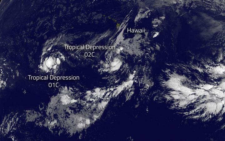
NOAA's GOES-West satellite saw that Hawaii is in the middle of a triangle of tropical cyclones. Tropical Depression 02C formed over 700 hundred miles south-southeast of Hawaii on July 10.
There are three tropical cyclones in the Central Pacific Ocean and Hawaii is in the middle of them. On July 10, newborn Tropical Depression 01C was west of Hawaii, while newborn Tropical Depression 02C was south of the Big Island. Post-Tropical Depression Ela was fizzling northeast of Hawaii.
NOAA's GOES-West satellite provided an infrared image of the newborn depression that showed bands of thunderstorms from the west of center, wrapping south to east of the center of circulation. The image was created from NASA/NOAA's GOES Project at NASA's Goddard Space Flight Center in Greenbelt, Maryland
At 5 a.m. HST (11 a.m. EDT/1500 UTC) the center of Tropical Depression Two-C (TD2C) was located near latitude 11.4 north and 155.2 west. That puts the storm about about 705 miles (1,135 km) south-southeast of Honolulu Hawaii and about 575 miles (920 km) south of Hilo, Hawaii. TD1C was moving toward the northwest near 6 mph (9 kph) and is expected to turn to the west on July 11.
NOAA's Central Pacific Hurricane Center noted that maximum sustained winds were near 35 mph (55 kph) with higher gusts. The depression is expected to reach tropical storm strength later today. The estimated minimum central pressure is 1005 millibars.
There are three tropical cyclones in the Central Pacific Ocean and Hawaii is in the middle of them. On July 10, newborn Tropical Depression 01C was west of Hawaii, while newborn Tropical Depression 02C was south of the Big Island. Post-Tropical Depression Ela was fizzling northeast of Hawaii.
NOAA's GOES-West satellite provided an infrared image of the newborn depression that showed bands of thunderstorms from the west of center, wrapping south to east of the center of circulation. The image was created from NASA/NOAA's GOES Project at NASA's Goddard Space Flight Center in Greenbelt, Maryland
At 5 a.m. HST (11 a.m. EDT/1500 UTC) the center of Tropical Depression Two-C (TD2C) was located near latitude 11.4 north and 155.2 west. That puts the storm about about 705 miles (1,135 km) south-southeast of Honolulu Hawaii and about 575 miles (920 km) south of Hilo, Hawaii. TD1C was moving toward the northwest near 6 mph (9 kph) and is expected to turn to the west on July 11.
NOAA's Central Pacific Hurricane Center noted that maximum sustained winds were near 35 mph (55 kph) with higher gusts. The depression is expected to reach tropical storm strength later today. The estimated minimum central pressure is 1005 millibars.
INFORMATION: