NASA sees fading post-Tropical Cyclone John's warmer cloud tops
Post-tropical cyclone John has been "flushed" out of existence in the eastern Pacific Ocean, and infrared NASA imagery revealed warmer cloud top temperatures and virtually no precipitation from John's remnants on Sept. 4.
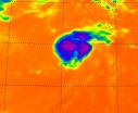
When NASA's Aqua satellite flew over post-tropical storm John on Sept. 4 at 21:23 UTC (5:23 p.m. EDT) the Atmospheric Infrared Sounder (AIRS) instrument revealed that cloud top temperatures in the storm had warmed over the previous 24 hours. AIRS data also showed there was one very tiny area of convection (rising air that forms the thunderstorms that ...