NASA sees Hurricane Lane punched in the eye
Published 2012-09-19 · Original archive entry · Explore research explainers
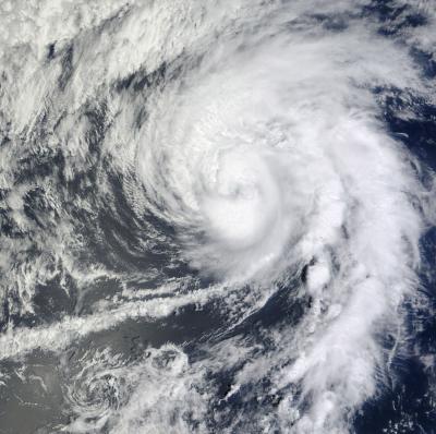
Powerful thunderstorms wrapped tightly around Hurricane Lane's center as it continued moving through the eastern Pacific Ocean. When NASA's Terra satellite passed over Lane it captured a close-up view of the storm and noticed that Lane's eye had become cloud-filled as if being punched in the eye. Nature is expected to fight Lane more and win over the next couple of days.
The Moderate Resolution Imaging Spectroradiometer (MODIS) instrument captured a close-up of Lane on Sept. 17 at 3:25 p.m. EDT when it was still a hurricane. In the image, Lane's eye appeared obscured by clouds as towering thunderstorms wrapped tightly around the center of circulation.
By Tuesday, Sept. 18 at 11 a.m. EDT, Lane weakened to a tropical storm. Lane's maximum sustained winds had fallen to 70 mph (110 kmh). It was centered about 1,170 miles (1,885 km) west of the southern tip of Baja California, near 20.1 North latitude and 127.9 West longitude. It was moving to the north near 9 mph (15 kmh) and is expected to turn to the northwest.
Those towering cloud tops surrounding Lane's entire eye had warmed on Tuesday, Sept. 18, indicating that they are not as high, and weaker.
Forecasters at the National Hurricane Center expect that Lane will be punched all over, not just "in the eye." There are two factors that are giving Lane a beating on Sept. 18 and 19, and those are cooler waters and increased wind shear. Lane is moving into an area where sea surface temperatures are colder than 22 Celsius (71.6 Fahrenheit), far below the 26.6C (80F) threshold needed for keeping a tropical cyclone alive. In addition, wind shear is forecast to increase from the southwest and pummel Lane at speeds of 25 knots (28.7 mph/46.3 kph), eventually "knocking it out." Lane is expected to become a remnant low pressure area by Wed., Sept. 19.
INFORMATION:
The Moderate Resolution Imaging Spectroradiometer (MODIS) instrument captured a close-up of Lane on Sept. 17 at 3:25 p.m. EDT when it was still a hurricane. In the image, Lane's eye appeared obscured by clouds as towering thunderstorms wrapped tightly around the center of circulation.
By Tuesday, Sept. 18 at 11 a.m. EDT, Lane weakened to a tropical storm. Lane's maximum sustained winds had fallen to 70 mph (110 kmh). It was centered about 1,170 miles (1,885 km) west of the southern tip of Baja California, near 20.1 North latitude and 127.9 West longitude. It was moving to the north near 9 mph (15 kmh) and is expected to turn to the northwest.
Those towering cloud tops surrounding Lane's entire eye had warmed on Tuesday, Sept. 18, indicating that they are not as high, and weaker.
Forecasters at the National Hurricane Center expect that Lane will be punched all over, not just "in the eye." There are two factors that are giving Lane a beating on Sept. 18 and 19, and those are cooler waters and increased wind shear. Lane is moving into an area where sea surface temperatures are colder than 22 Celsius (71.6 Fahrenheit), far below the 26.6C (80F) threshold needed for keeping a tropical cyclone alive. In addition, wind shear is forecast to increase from the southwest and pummel Lane at speeds of 25 knots (28.7 mph/46.3 kph), eventually "knocking it out." Lane is expected to become a remnant low pressure area by Wed., Sept. 19.
INFORMATION: