NASA sees Tropical Storm Son-tinh moving through South China Sea
Published 2012-10-26 · Original archive entry · Explore research explainers
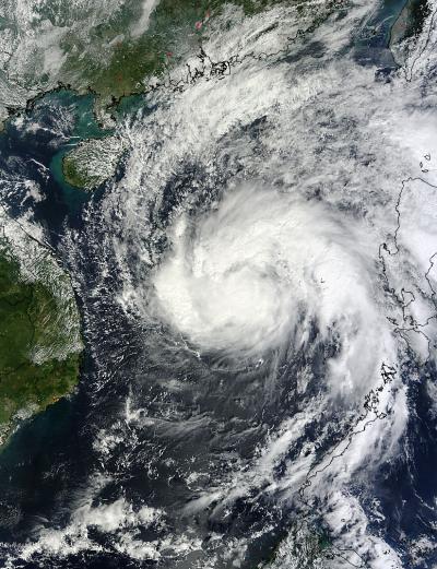
NASA's Terra satellite got a good look at Tropical Storm Son-tinh moving through the South China Sea and headed for landfall in Vietnam.
NASA's Terra satellite flew over Son-Tinh on Oct. 26 at 0305 UTC (Oct. 25 at 11:05 p.m. EDT) and the Moderate Resolution Imaging Spectroradiometer (MODIS) instrument aboard captured a visible image of the storm. At the time, Son-tinh's western edge had already moved away from the Philippines. The image revealed powerful thunderstorms in the northwestern quadrant of the storm, and in the storm's center.
On Oct. 26 at 1500 UTC, Tropical Storm Son-tinh had maximum sustained winds near 60 knots (69 mph/111 kph). It was centered near 15.7 North latitude and 113.0 East longitude, about 355 nautical miles (408.5 miles/657 km) east of Hue, Vietnam. Son-tinh is moving to the west-northwest at 11 knots (12.6 mph/20.3 kph) and is expected to make a landfall south of Hanoi early on Oct. 28.
INFORMATION:
NASA's Terra satellite flew over Son-Tinh on Oct. 26 at 0305 UTC (Oct. 25 at 11:05 p.m. EDT) and the Moderate Resolution Imaging Spectroradiometer (MODIS) instrument aboard captured a visible image of the storm. At the time, Son-tinh's western edge had already moved away from the Philippines. The image revealed powerful thunderstorms in the northwestern quadrant of the storm, and in the storm's center.
On Oct. 26 at 1500 UTC, Tropical Storm Son-tinh had maximum sustained winds near 60 knots (69 mph/111 kph). It was centered near 15.7 North latitude and 113.0 East longitude, about 355 nautical miles (408.5 miles/657 km) east of Hue, Vietnam. Son-tinh is moving to the west-northwest at 11 knots (12.6 mph/20.3 kph) and is expected to make a landfall south of Hanoi early on Oct. 28.
INFORMATION: