NASA sees Hurricane Sandy as the "Bride of Frankenstorm" approaching the US East Coast
VIDEO:
An animation of NOAA's GOES-13 satellite observations from Oct. 24-26, 2012, shows Hurricane Sandy crossing eastern Cuba and moving through and exiting the Bahamas. This visualization was created by the...
Click here for more information.
NASA's TRMM satellite revealed Hurricane Sandy's heavy rainfall and the storm is expected to couple with a powerful cold front and Arctic air to bring that heavy rainfall to the Mid-Atlantic and northeastern U.S. Some forecasters are calling this combination of weather factors "Frankenstorm" because of the close proximity to Halloween. However, because Sandy is a woman's name, the storm could be considered a "bride of Frankenstorm."
NASA satellites have provided forecasters at the National Hurricane Center with rainfall data, infrared, visible and other data on Sandy and will continue to do so. Dr. Marshall Shepherd who works with TRMM data provided an insight into the storm's development.
NASA's TRMM Satellite Sees Sandy Drench Jamaica and Eastern Cuba
The Tropical Rainfall Measuring Mission (TRMM) satellite had a partial view of hurricane Sandy on Oct. 25 at 1425 UTC (10:25 a.m. EDT) after it had passed over Cuba and moved into the Bahamas. An eye was hard to find but TRMM's Microwave Imager (TMI) data showed that a large area of intense rainfall was occurring around Sandy's center of circulation. Hal Pierce of NASA's TRMM Team at NASA's Goddard Space Flight Center in Greenbelt, Md. used a GOES-13 satellite image captured at the same time to fill in the part of the image not viewed by TRMM to create a total picture of the storm.
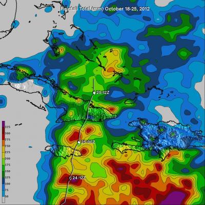
With its combination of passive microwave and active radar sensors, TRMM is ideally suited to measure rainfall from space. For increased coverage, TRMM can be used to calibrate rainfall estimates from other additional satellites. The TRMM-based, near-real time Multi-satellite Precipitation Analysis (TMPA) made at NASA Goddard can be used to rainfall over a wide portion of the globe. TMPA rainfall totals were tallied for the seven-day period from Oct. 18-25, 2012.The heaviest rainfall occurred over open ocean where totals were as high as 325 millimeters. Rainfall amounts as high as 250 millimeters were measured over eastern Cuba and some extreme southern areas of Hispaniola.
Hurricane Sandy passed over the islands of Jamaica and Cuba causing at least 21 deaths. Extensive flooding and other damage were reported near the capital city of Kingston and other areas of Jamaica.
National Hurricane Center Rainfall Expectations
The heavy rainfall potential is evident in the National Hurricane Center's (NHC) forecast on Oct. 26. The NHC noted that Sandy is expected to produce total rainfall amounts of 6 to 12 inches across Haiti and the Dominican Republic with isolated maximum totals of 20 inches possible. Rainfall totals of 3 to 6 inches are expected over portions of the Bahamas with isolated maximum amounts of 12 inches possible. Rainfall totals of one to three inches are expected across the Florida Keys into southeastern and east-central Florida with isolated maximum amounts of six inches possible. Rainfall totals of 4 to 8 inches are possible over far eastern North Carolina.
Interview with Research Meteorologist Dr. Marshall Shepherd
Dr. Marshall Shepherd, University of Georgia Professor and Research Meteorologist has worked with TRMM satellite data since its launch in 1997. Dr. Shepherd provided his take on the storm event. "Models are coming into consensus on a landfall, if you will, in the DelMarVa area. Comparisons are being made to the Perfect Storm of 1991, but many folks won't remember that. Storm will bring very strong winds (hurricane force) over a strong area. Remember the Derecho of June 29, 2012. Expand that to the entire Delaware/Maryland/Virginia and New York/New Jersey region."
Shepherd said that the event will bring significant rains and inland freshwater flooding , that he said was often the deadliest threat from tropical systems. He also cited concerns about the storm surge and coastal flooding as full moon will mean elevated water levels/tides coupled with the storm-induced surge. Finally, he noted, there is likely to be heavy wet snow into the inland and higher elevations of the effected region. "Pay attention to the cone or area of influence rather than a specific track as the storm will affect an area not a point," he said.
"Advances from NASA satellites, aircraft, and models are essential for ingest into the models, assessing storm locations and intensity, and testing future modeling techniques," he said. "It may not be obvious to many, but our warning and prediction capability does have traceability to the NASA program in numerous ways and I have been happy to play some small role as a former NASA scientist and current member of the NASA Precipitation Science Team and Earth Science Subcommittee of the NASA Advisory Council."
Where is Sandy on Friday, Oct. 26?
A Hurricane Warning is in effect for the Northwestern Bahamas Except Andros Island. A Tropical Storm Warning is in effect for the Central Bahamas, Florida East Coast from Ocean Reef to Flagler Beach, Lake Okeechobee and Andros Island in the northwestern Bahamas. A Tropical Storm Watch is in effect for Savannah River to Oregon Inlet North Carolina, Pamlico Sound, the Florida east coast from North of Flagler Beach to Fernandina Beach, the Florida Upper Keys from Ocean Reef to Craig Key, and Florida Bay.
On Friday, Oct. 26, at 8 a.m. EDT, Hurricane Sandy's maximum sustained winds were near 80- mph (130 kph). Sandy is a category one hurricane on the Saffir-Simpson Hurricane wind scale. Some weakening is possible during the next day or so, according to the National Hurricane Center. It was centered near latitude 26.4 north and longitude 76.9 west. Sandy is moving northwest near 10 mph (17 kph) and is expected to turn north and then northeast on Oct. 27, while slowing down.
Storm surge is expected to be big factor as Sandy approaches the Mid-Atlantic coast. Very rough surf and high and dangerous waves are expected to be coupled with the full moon. The National Hurricane Center noted that the combination of a dangerous storm surge and the tide will cause normally dry areas near the coast to be flooded by rising waters. The water could reach the following depths above ground if the peak surge occurs at the time of high tide. Some storm surge forecasts include: 5 to 8 feet in the hurricane warning area in the Bahamas and one to three feet along the Florida coast in the warning areas on Oct. 26.
GOES-13 Satellite Shows Sandy and Powerful Cold Front
NOAA's GOES-13 satellite monitors weather over the eastern U.S. and the Atlantic Ocean. In a visible image taken from NOAA's GOES-13 satellite on Friday, Oct. 26 at 1415 UTC (10:15 a.m. EDT) Hurricane Sandy's huge cloud extent of up to 2,000 miles extended into the Atlantic, while its center was over the Bahamas. At the same time a long line of clouds associated with a powerful cold front approaching the U.S. east coast stretched from the upper Midwest to the Gulf coast. The image was created by the NASA GOES Project at NASA Goddard.
"Bride of Frankenstorm"
Hurricane Sandy is expected to mix with a powerful cold front approaching the east coast, and cold Arctic Air mass, setting up for a powerful storm, a "Bride of Frankenstorm."
The cold front stretching from the upper Midwest to the Gulf coast is moving eastward and is expected to temporarily push Sandy away from the coast. However, the front is expected to break down as it moves toward the coast, allowing Hurricane Sandy to come back toward the coast.
As happens when any storm becomes extra-tropical, Sandy will go from a warm to cold core center and the strongest winds spread out and the storm will expand. According to the National Hurricane Center, hurricane force winds extend outward up to 35 miles (55 km) from the center and tropical storm force winds extend outward up to 275 miles (445 km). The wind field of Sandy is expected to grow in size during the next couple of days. The storm's circulation almost reaches 2,000 miles.
Although landfall is expected in southeastern Delaware early Tuesday morning as a hurricane, the Mid-Atlantic is expected to start feeling the storm's effect starting Sunday, Oct. 28.
INFORMATION:
Click here for more information.
NASA's TRMM satellite revealed Hurricane Sandy's heavy rainfall and the storm is expected to couple with a powerful cold front and Arctic air to bring that heavy rainfall to the Mid-Atlantic and northeastern U.S. Some forecasters are calling this combination of weather factors "Frankenstorm" because of the close proximity to Halloween. However, because Sandy is a woman's name, the storm could be considered a "bride of Frankenstorm."
NASA satellites have provided forecasters at the National Hurricane Center with rainfall data, infrared, visible and other data on Sandy and will continue to do so. Dr. Marshall Shepherd who works with TRMM data provided an insight into the storm's development.
NASA's TRMM Satellite Sees Sandy Drench Jamaica and Eastern Cuba
The Tropical Rainfall Measuring Mission (TRMM) satellite had a partial view of hurricane Sandy on Oct. 25 at 1425 UTC (10:25 a.m. EDT) after it had passed over Cuba and moved into the Bahamas. An eye was hard to find but TRMM's Microwave Imager (TMI) data showed that a large area of intense rainfall was occurring around Sandy's center of circulation. Hal Pierce of NASA's TRMM Team at NASA's Goddard Space Flight Center in Greenbelt, Md. used a GOES-13 satellite image captured at the same time to fill in the part of the image not viewed by TRMM to create a total picture of the storm.
With its combination of passive microwave and active radar sensors, TRMM is ideally suited to measure rainfall from space. For increased coverage, TRMM can be used to calibrate rainfall estimates from other additional satellites. The TRMM-based, near-real time Multi-satellite Precipitation Analysis (TMPA) made at NASA Goddard can be used to rainfall over a wide portion of the globe. TMPA rainfall totals were tallied for the seven-day period from Oct. 18-25, 2012.The heaviest rainfall occurred over open ocean where totals were as high as 325 millimeters. Rainfall amounts as high as 250 millimeters were measured over eastern Cuba and some extreme southern areas of Hispaniola.
Hurricane Sandy passed over the islands of Jamaica and Cuba causing at least 21 deaths. Extensive flooding and other damage were reported near the capital city of Kingston and other areas of Jamaica.
National Hurricane Center Rainfall Expectations
The heavy rainfall potential is evident in the National Hurricane Center's (NHC) forecast on Oct. 26. The NHC noted that Sandy is expected to produce total rainfall amounts of 6 to 12 inches across Haiti and the Dominican Republic with isolated maximum totals of 20 inches possible. Rainfall totals of 3 to 6 inches are expected over portions of the Bahamas with isolated maximum amounts of 12 inches possible. Rainfall totals of one to three inches are expected across the Florida Keys into southeastern and east-central Florida with isolated maximum amounts of six inches possible. Rainfall totals of 4 to 8 inches are possible over far eastern North Carolina.
Interview with Research Meteorologist Dr. Marshall Shepherd
Dr. Marshall Shepherd, University of Georgia Professor and Research Meteorologist has worked with TRMM satellite data since its launch in 1997. Dr. Shepherd provided his take on the storm event. "Models are coming into consensus on a landfall, if you will, in the DelMarVa area. Comparisons are being made to the Perfect Storm of 1991, but many folks won't remember that. Storm will bring very strong winds (hurricane force) over a strong area. Remember the Derecho of June 29, 2012. Expand that to the entire Delaware/Maryland/Virginia and New York/New Jersey region."
Shepherd said that the event will bring significant rains and inland freshwater flooding , that he said was often the deadliest threat from tropical systems. He also cited concerns about the storm surge and coastal flooding as full moon will mean elevated water levels/tides coupled with the storm-induced surge. Finally, he noted, there is likely to be heavy wet snow into the inland and higher elevations of the effected region. "Pay attention to the cone or area of influence rather than a specific track as the storm will affect an area not a point," he said.
"Advances from NASA satellites, aircraft, and models are essential for ingest into the models, assessing storm locations and intensity, and testing future modeling techniques," he said. "It may not be obvious to many, but our warning and prediction capability does have traceability to the NASA program in numerous ways and I have been happy to play some small role as a former NASA scientist and current member of the NASA Precipitation Science Team and Earth Science Subcommittee of the NASA Advisory Council."
Where is Sandy on Friday, Oct. 26?
A Hurricane Warning is in effect for the Northwestern Bahamas Except Andros Island. A Tropical Storm Warning is in effect for the Central Bahamas, Florida East Coast from Ocean Reef to Flagler Beach, Lake Okeechobee and Andros Island in the northwestern Bahamas. A Tropical Storm Watch is in effect for Savannah River to Oregon Inlet North Carolina, Pamlico Sound, the Florida east coast from North of Flagler Beach to Fernandina Beach, the Florida Upper Keys from Ocean Reef to Craig Key, and Florida Bay.
On Friday, Oct. 26, at 8 a.m. EDT, Hurricane Sandy's maximum sustained winds were near 80- mph (130 kph). Sandy is a category one hurricane on the Saffir-Simpson Hurricane wind scale. Some weakening is possible during the next day or so, according to the National Hurricane Center. It was centered near latitude 26.4 north and longitude 76.9 west. Sandy is moving northwest near 10 mph (17 kph) and is expected to turn north and then northeast on Oct. 27, while slowing down.
Storm surge is expected to be big factor as Sandy approaches the Mid-Atlantic coast. Very rough surf and high and dangerous waves are expected to be coupled with the full moon. The National Hurricane Center noted that the combination of a dangerous storm surge and the tide will cause normally dry areas near the coast to be flooded by rising waters. The water could reach the following depths above ground if the peak surge occurs at the time of high tide. Some storm surge forecasts include: 5 to 8 feet in the hurricane warning area in the Bahamas and one to three feet along the Florida coast in the warning areas on Oct. 26.
GOES-13 Satellite Shows Sandy and Powerful Cold Front
NOAA's GOES-13 satellite monitors weather over the eastern U.S. and the Atlantic Ocean. In a visible image taken from NOAA's GOES-13 satellite on Friday, Oct. 26 at 1415 UTC (10:15 a.m. EDT) Hurricane Sandy's huge cloud extent of up to 2,000 miles extended into the Atlantic, while its center was over the Bahamas. At the same time a long line of clouds associated with a powerful cold front approaching the U.S. east coast stretched from the upper Midwest to the Gulf coast. The image was created by the NASA GOES Project at NASA Goddard.
"Bride of Frankenstorm"
Hurricane Sandy is expected to mix with a powerful cold front approaching the east coast, and cold Arctic Air mass, setting up for a powerful storm, a "Bride of Frankenstorm."
The cold front stretching from the upper Midwest to the Gulf coast is moving eastward and is expected to temporarily push Sandy away from the coast. However, the front is expected to break down as it moves toward the coast, allowing Hurricane Sandy to come back toward the coast.
As happens when any storm becomes extra-tropical, Sandy will go from a warm to cold core center and the strongest winds spread out and the storm will expand. According to the National Hurricane Center, hurricane force winds extend outward up to 35 miles (55 km) from the center and tropical storm force winds extend outward up to 275 miles (445 km). The wind field of Sandy is expected to grow in size during the next couple of days. The storm's circulation almost reaches 2,000 miles.
Although landfall is expected in southeastern Delaware early Tuesday morning as a hurricane, the Mid-Atlantic is expected to start feeling the storm's effect starting Sunday, Oct. 28.
INFORMATION: