New satellite driven model provides “more realistic and reliable” predictions of sand and dust storm emissions
Cardiff-led team tackles decades-long problem of overestimating when and where sediment transport occurs
New satellite driven model provides “more realistic and reliable” predictions of sand and dust storm emissions
Cardiff-led team tackles decades-long problem of overestimating when and where sediment transport occurs
The technology used to predict sand and dust storm (SDS) severity has for decades systematically over-estimated when and where sediment is transported across the Earth’s surface, a new study shows.
Existing models, which draw on satellite, surface, Light Detection and Ranging (LiDAR) and weather data, make emission predictions and underpin early warning systems to try and reduce the health and climate impacts of SDS events globally.
However, model effectiveness is limited by the long-standing assumption that soil surfaces on Earth never change, argues the international team of researchers, led by Cardiff University.
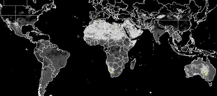
Their study, published in Nature Communications Earth and Environment, presents an alternative satellite driven model (dEARTH) that dynamically tracks how soil surfaces change over time.
dEARTH incorporates real world conditions such as crusting, roughness, vegetation shielding, and changing sediment supply — all detected and measured by space satellites.
This new approach is essential for modern Earth system modelling, say the researchers — especially during the UN Decade to Combat Sand and Dust Storms (2025–2034).
Lead author Dr Zhuoli Zhou from Cardiff University’s School of Earth and Environmental Sciences, said: “For nearly four decades, existing models have treated the wind strength needed to initiate sediment transport as constant. Coupled with this is their assumption that there is always sufficient loose material available for transport, treating soil surfaces as the same and static over time.
“This can misrepresent the way the wind moves sediment across the Earth’s surface — a process that affects our climate, air quality, land degradation, and global dust storms.
“Our study offers a solution to this problem by capturing changes in real surface roughness and soil conditions over time.
“While this does not make us any less vulnerable to the health and climate impacts of SDS, accounting for these dynamic conditions provides more realistic and reliable estimates of where and how often wind-driven sediment transport occurs.”
The team tested dEARTH against existing models using 2024 conditions.
They found:
“This is important because it indicates that existing models lacking dynamic surface feedback may systematically overestimate erosion extent and fluxes, limiting their reliability for dust emission modelling and early warning systems.”
The team intends to integrate dynamic thresholds such as those used by dEARTH into operational dust emission and early warning models in the future.
Their vision is to provide a satellite remote sensing platform for global monitoring of wind erosion and dust emission. This monitoring system will then enable applications for land management and long-term environmental change.
Co-author Professor Adrian Chappell, also based at Cardiff University’s School of Earth and Environmental Sciences, said: “New technological advances enable new model developments to challenge simplifying model assumptions so that we more realistically represent the processes of sediment transport and dust emission.
“The conventional modelling approach relies on numerical description of the factors controlling the processes everywhere, all the time. This is incredibly difficult to achieve when there is so much variability over space and time. Instead, we make use of optical satellite remote sensing to represent that variability. The challenge then is to convert that reflectance data into information that explain wind erosion and dust emission.
“As a result, we now have a model which for the first time since models were developed more than 30 years ago, describes the way entrainment changes over space and time. Early warning systems for sand and dust storms, climate–dust interaction models, air quality hazard systems and global land degradation assessments can now represent the frequency and magnitude of sediment transport and dust emission, which should improve the reliability of the models, their forecast performance and the effectiveness of mitigation policy and practice at regional and global scales.”
ENDS
END
Cardiff-led team tackles decades-long problem of overestimating when and where sediment transport occurs
The technology used to predict sand and dust storm (SDS) severity has for decades systematically over-estimated when and where sediment is transported across the Earth’s surface, a new study shows.
Existing models, which draw on satellite, surface, Light Detection and Ranging (LiDAR) and weather data, make emission predictions and underpin early warning systems to try and reduce the health and climate impacts of SDS events globally.
However, model effectiveness is limited by the long-standing assumption that soil surfaces on Earth never change, argues the international team of researchers, led by Cardiff University.
Their study, published in Nature Communications Earth and Environment, presents an alternative satellite driven model (dEARTH) that dynamically tracks how soil surfaces change over time.
dEARTH incorporates real world conditions such as crusting, roughness, vegetation shielding, and changing sediment supply — all detected and measured by space satellites.
This new approach is essential for modern Earth system modelling, say the researchers — especially during the UN Decade to Combat Sand and Dust Storms (2025–2034).
Lead author Dr Zhuoli Zhou from Cardiff University’s School of Earth and Environmental Sciences, said: “For nearly four decades, existing models have treated the wind strength needed to initiate sediment transport as constant. Coupled with this is their assumption that there is always sufficient loose material available for transport, treating soil surfaces as the same and static over time.
“This can misrepresent the way the wind moves sediment across the Earth’s surface — a process that affects our climate, air quality, land degradation, and global dust storms.
“Our study offers a solution to this problem by capturing changes in real surface roughness and soil conditions over time.
“While this does not make us any less vulnerable to the health and climate impacts of SDS, accounting for these dynamic conditions provides more realistic and reliable estimates of where and how often wind-driven sediment transport occurs.”
The team tested dEARTH against existing models using 2024 conditions.
They found:
- a 69% smaller global area was affected by sediment transport;
- 45% lower total global sediment was transported.
“This is important because it indicates that existing models lacking dynamic surface feedback may systematically overestimate erosion extent and fluxes, limiting their reliability for dust emission modelling and early warning systems.”
The team intends to integrate dynamic thresholds such as those used by dEARTH into operational dust emission and early warning models in the future.
Their vision is to provide a satellite remote sensing platform for global monitoring of wind erosion and dust emission. This monitoring system will then enable applications for land management and long-term environmental change.
Co-author Professor Adrian Chappell, also based at Cardiff University’s School of Earth and Environmental Sciences, said: “New technological advances enable new model developments to challenge simplifying model assumptions so that we more realistically represent the processes of sediment transport and dust emission.
“The conventional modelling approach relies on numerical description of the factors controlling the processes everywhere, all the time. This is incredibly difficult to achieve when there is so much variability over space and time. Instead, we make use of optical satellite remote sensing to represent that variability. The challenge then is to convert that reflectance data into information that explain wind erosion and dust emission.
“As a result, we now have a model which for the first time since models were developed more than 30 years ago, describes the way entrainment changes over space and time. Early warning systems for sand and dust storms, climate–dust interaction models, air quality hazard systems and global land degradation assessments can now represent the frequency and magnitude of sediment transport and dust emission, which should improve the reliability of the models, their forecast performance and the effectiveness of mitigation policy and practice at regional and global scales.”
ENDS
END