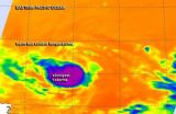
Tropical Storm Karina: status quo on infrared satellite imagery
Since Tropical Storm Karina weakened from hurricane status, and since then, NASA satellite data has shown that the storm has been pretty consistent with strength and thunderstorm development.
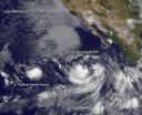
Hurricane Karina formed on August 13, 2014 off the Mexican coast. The Tropical Rainfall Measuring Mission or TRMM satellite passed directly above the center of intensifying tropical storm Karina on August 14, 2014 at 1927 UTC (3:27 p.m. EDT). TRMM's Microwave Imager showed that storms near Karina's center were dropping rain at a rate of over 50mm (almost 2 inches) per hour. After ...