Whitehead scientists bring new efficiency to stem cell reprogramming
CAMBRIDGE, Mass. (September 13, 2012) – Several years ago, biologists discovered that regular body cells can be reprogrammed into pluripotent stem cells — cells with the ability to become any other type of cell. Such cells hold great promise for treating many human diseases.
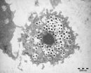
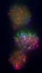
These induced pluripotent stem cells (iPSCs) are usually created by genetically modifying cells to overexpress four genes that make them revert to an immature, embryonic state. However, the procedure works in only a small percentage of cells.
Now, new genetic markers identified by researchers at ...