Under Sao Paulo, 14,000 wells tap water that nobody is testing for toxic solvents
Published in Environmental Earth Sciences. DOI: 10.1007/s12665-025-12727-x. Supported by FAPESP. Institution: Institute of Geosciences, University of Sao Paulo.
Sao Paulo's metropolitan area is home to 22 million people who consume an average of 61,600 liters of water per second. Nearly all the public supply comes from surface sources — reservoirs, rivers, treatment plants. But roughly 18% of total water consumption flows from underground, drawn up through approximately 14,000 private wells that tap into the region's aquifers. These wells supply hospitals, condominium complexes, industrial facilities, and private clubs. They contribute an estimated 347 million cubic meters of water per year.
Two-thirds of those wells are not formally registered with any government authority.
Factories leave, chemicals stay
Sao Paulo's deindustrialization began in the late 1970s and accelerated through the 1980s. High urban costs drove manufacturers to outlying municipalities or other states entirely, leaving behind shuttered warehouses, abandoned lots, and contaminated soil. Former industrial districts were repurposed for commerce, housing, and real estate developments — often in areas that had never been assessed for subsurface pollution.
The contaminants of greatest concern are chlorinated solvents, particularly perchloroethylene (C2Cl4) and trichloroethylene (C2HCl3). Both were widely used as industrial degreasers for cleaning metal parts. Perchloroethylene also served as the primary solvent in dry cleaning for decades. While Brazilian regulations now restrict its use, the chemicals persist underground in ways that other pollutants do not.
Unlike hydrocarbon spills from gas stations, which tend to degrade relatively quickly in soil, chlorinated solvents are stubborn. They resist natural breakdown. Worse, when degradation does occur, the resulting daughter compounds can be more toxic than the originals. And the quantities needed to cause harm are vanishingly small — potability limits are measured in parts per billion.
Three maps, one alarming overlap
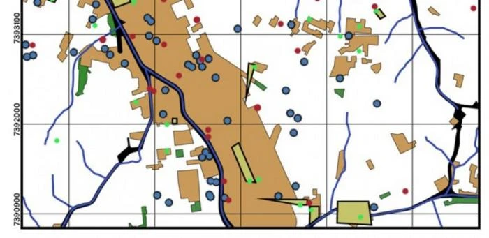
A study published in Environmental Earth Sciences, led by postdoctoral researcher Daphne Silva Pino at the University of Sao Paulo's Institute of Geosciences, performed something deceptively straightforward: it layered three datasets onto a single map. The first layer showed current and former industrial zones. The second marked sites officially contaminated by chlorinated solvents. The third plotted the locations of registered water supply wells.
The overlap was extensive. In neighborhoods like Mooca — one of Sao Paulo's most dramatically deindustrialized districts — registered wells sat within or adjacent to known contamination zones. Some wells appeared inside green polygons that designate areas where water extraction should not occur at all. And these maps only show the wells authorities know about. The unregistered majority doesn't appear.
Applying the state's own regulatory criterion — which requires water quality reporting when a contaminated area falls within 500 meters of a well — the researchers identified 17 clusters where contamination plumes and well radii overlapped. These clusters appeared in Jurubatuba, Jaguare, Mooca, and Vila Prudente within the city of Sao Paulo, and in Diadema, Maua, and Osasco across the broader metropolitan area.
Property lines versus plume lines
The study highlights a fundamental mismatch between how contamination is managed and how it behaves. Remediation in Brazil typically operates at the property boundary. A contaminated industrial lot gets assessed, and cleanup targets are set for that parcel. Topsoil is removed to prevent toxic vapors from entering buildings. But the contaminant mass deep underground doesn't respect property lines. Groundwater carries it laterally and, when deep wells pump from below, the resulting hydraulic gradient pulls contaminated shallow water downward toward extraction points at depths of 100 meters or more.
Less permeable geological layers can act as natural filters between the shallow contamination zone and deeper aquifer levels. But co-author Reginaldo Antonio Bertolo, a professor at USP's Institute of Geosciences, acknowledges significant uncertainty about how well that filtration holds up over decades of continuous pumping.
596 sites, most still in limbo
When the researchers examined Sao Paulo's state contamination registry, they found 596 areas with a documented history of chlorinated solvent contamination. By 2020, only 18.6% had been classified as rehabilitated for their declared use — a designation that doesn't mean the contaminants are gone, only that risk levels have been deemed acceptable. More than half remained in active remediation. Another 26% were still under investigation.
Jurubatuba, in southern Sao Paulo, is the most studied area in the metro region and is cited in the paper as a potential pilot for broader coordinated action. Even there, three-quarters of contaminated sites lack detailed information in environmental registries. Half of those sites are industrial facilities with documented histories of solvent use.
The scale problem
The core challenge is one of governance at scale. Individual site remediation, conducted property by property, cannot address contamination plumes that span neighborhoods. Multiple contaminated sites in the same area create intersecting plumes — what the researchers call multipoint sources — with deep wells for human consumption sitting within these overlapping contamination belts.
The study's authors argue for a shift from case-by-case management to regional hydrogeological assessment. That means treating connected groundwater systems as single units, regardless of the property boundaries above them. It means building more robust databases that link well locations, contamination histories, and groundwater flow models. And it means deploying multidisciplinary technical teams capable of evaluating risk at a scale that matches the actual movement of water underground.
None of this is simple. The well registration problem alone represents a regulatory gap that has been growing for decades. Getting two-thirds of private wells onto the books would require enforcement resources that Sao Paulo's environmental agencies currently lack. And even registered wells in known contamination zones may not be submitting the water quality reports that state law requires.
What remains unknown
The study acknowledges several limitations. The contamination registry likely underestimates the true number of affected sites, since many former industrial properties have never been assessed. The behavior of chlorinated solvents at depth over long time periods is not fully characterized. And the health effects on populations consuming water from unmonitored wells in contaminated areas remain unmeasured — a data gap that is itself a form of risk.
Still, the cartographic evidence is difficult to dismiss. In a metro area of 22 million people, thousands of unregistered wells are drawing water from aquifers that sit beneath decades of industrial contamination, and the monitoring systems that should catch problems before they reach consumers are largely absent.