NASA sees Tropical Storm Maliksi put final touches on Japan
Published 2012-10-05 · Original archive entry · Explore research explainers
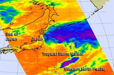
Tropical Storm Maliksi is putting the final touches on Japan, that is, the edge of the storm was seen brushing the country's northern coast as it pulled away on NASA satellite imagery.
NASA's Aqua satellite passed over Tropical Storm Maliksi on Oct. 4 at 0329 UTC (11:29 p.m. EDT, Oct. 3, EDT) and the Atmospheric Infrared Sounder (AIRS) instrument captured an infrared image of the storm brushing the Tohoku and Hokkaido prefectures of northern Japan.
On Oct. 4, 2012 at 1500 UTC (11 a.m. EDT), the Joint Typhoon Warning Center issued their final advisory on Maliksi. At that time it had maximum sustained winds near 45 knots (51.7 mph/83.3 kph). It was centered near 32.6 North and 144.8 East, about 330 nautical miles (380 miles/611 km) southeast of Yokosuka, Japan. Maliksi was moving to the north-northeast at a speedy 32 knots (37 mph/59 kph).
Wind shear from the southwest has pushed most of the showers and thunderstorms northeast of the center of circulation, as was visible in the AIRS imagery.
The storm is becoming extra-tropical and is expected to become a cold core storm (instead of a warm core tropical cyclone) later in the day on Oct. 4.
INFORMATION:
NASA's Aqua satellite passed over Tropical Storm Maliksi on Oct. 4 at 0329 UTC (11:29 p.m. EDT, Oct. 3, EDT) and the Atmospheric Infrared Sounder (AIRS) instrument captured an infrared image of the storm brushing the Tohoku and Hokkaido prefectures of northern Japan.
On Oct. 4, 2012 at 1500 UTC (11 a.m. EDT), the Joint Typhoon Warning Center issued their final advisory on Maliksi. At that time it had maximum sustained winds near 45 knots (51.7 mph/83.3 kph). It was centered near 32.6 North and 144.8 East, about 330 nautical miles (380 miles/611 km) southeast of Yokosuka, Japan. Maliksi was moving to the north-northeast at a speedy 32 knots (37 mph/59 kph).
Wind shear from the southwest has pushed most of the showers and thunderstorms northeast of the center of circulation, as was visible in the AIRS imagery.
The storm is becoming extra-tropical and is expected to become a cold core storm (instead of a warm core tropical cyclone) later in the day on Oct. 4.
INFORMATION: