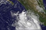
NASA marks Polo for a hurricane
Hurricane Polo still appears rounded in imagery from NOAA's GOES-West satellite, but forecasters at the National Hurricane Center expect that to change.
NOAA's GOES-West satellite captured data on Hurricane Polo on Sept. 18 at 10:15 a.m. EDT. An image using that data was created by the NASA/NOAA GOES Project at NASA's Goddard Space Flight Center in Greenbelt, Maryland. The image showed thunderstorms wrapping tightly around the center of the storm while one broken band of thunderstorms extended to the northwest, while the other appeared on the eastern side of the center ...